Watson Island (Miami)
| Watson Island | |
|---|---|
| Neighborhood of Miami | |

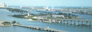
Watson Island and the MacArthur Causeway, with the Venetian Causeway in the foreground
|
|
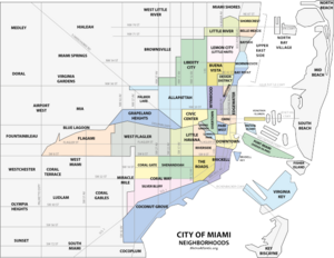
 Map of Miami neighborhoods. Watson Island is the smallest light-blue area, just above the western end of the elongated green Port of Miami area. |
|
| Country | United States |
| State | Florida |
| County | Miami-Dade County |
| City | Miami |
| Government | |
| • City of Miami Commissioner | Marc Sarnoff |
| • Miami-Dade County Commissioners | Bruno Barreiro and Audrey Edmonson |
| • House of Representatives | Carlos Lopez-Cantera (R) and Luis García, Jr. (R) |
| • State Senate | Gwen Margolis (D) |
| • U.S. House | Ileana Ros-Lehtinen (R) |
| Area | |
| • Total | 0.280 sq mi (0.73 km2) |
| Time zone | EST (UTC-05) |
| ZIP Code | 33132 |
| Area code(s) | 305, 786 |
Watson Island is a neighborhood and man-made island in Biscayne Bay, in Miami, Florida, United States. Immediately east of the CBD and Omni neighborhoods of Greater Downtown Miami, it is connected to the mainland and South Beach, Miami by the MacArthur Causeway.
The island was deeded to the city in 1919 with the restriction that it only be used for public or municipal purposes. The city gave it to the state and the state deeded it back to the city with similar restrictions - both in the 1940s. In 1979 the city attempted to circumvent this prohibition by claiming that the underwater land surrounding the island is a preserve and Watson Island need not be protected as per the deed, as a park, or for public ownership and use.
The island had a name change from Causeway Island to Watson Island, named for John W. Watson, Sr., who was Mayor of Miami 1912-1915 and 1917-1919. In 1932 Watson Island was considered for the site of Miami's Pan-American Exposition, a World's Fair and "International Merchandise mart." By the end of the 1940s, however, the site of the Exposition, now called Interama, was moved North to where Oleta River State Park is today.
A Goodyear Blimp base was located on Watson Island from 1930 to 1978, initially on the east side of the island and later on a new landfill area to the west. Goodyear moved the base to Opa-locka Airport after failing to agree on lease renewal terms with the city. Vestiges of the old base still remain such as the imprint of the mooring circle and a paved path for a small tram that would transport passengers to the airship.
Grand plans to develop the island started in 1979, with a planned amusement park, Diplomat World. Residents formed "Save Watson Island, Inc", a neighborhood group opposing the use for anything other than a park. They had public demonstrations and because of the demonstrations and a variety of other reasons, the amusement park was never built.
...
Wikipedia
