Waterview Connection

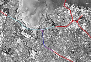
While generally considered a "tunnel project", the Waterview Connection also includes other large motorway works. The connection consists of the purple (above ground) and dark blue (bored tunnels) sections. The portion of SH16 requiring lane upgrades is shown in light blue.
|
|
| Location | Auckland, New Zealand |
|---|---|
| Proposer | New Zealand Transport Agency |
| Website | http://www.nzta.govt.nz/projects/waterviewconnection |
| Status | Under construction |
| Type | Road & tunnel |
| Cost estimate | $1.7 billion |
| Start date | Late 2011 |
| Completion date | April 2017 |
| Stakeholders | Government of New Zealand, New Zealand Transport Agency, Auckland Council, Campaign for Better Transport, Cycle Action Auckland, Friends of Oakley Creek, North West Community Association, various further community groups and submitters |

Tunnel cross-section, including an emergency cross-connection.
|
|
| Overview | |
|---|---|
| Route | Western Ring Route (State Highway 20) |
| Start | 2012 (tunnel boring started November 2013) |
| End | 2017 |
| Operation | |
| Constructed | 2011–2017 |
| Owner | New Zealand Transport Agency |
| Operator | New Zealand Transport Agency |
| Traffic | Motor vehicles |
| Character | Motorway |
| Toll | Not tolled |
| Vehicles per day | 83,000 by 2026 (estimated) |
| Technical | |
| Length | 2.5km |
| Number of lanes | 3 lanes each tunnel |
| Operating speed | 80km/hr |
The Waterview Connection is a motorway section under construction through west/central Auckland, New Zealand. It will connect State Highway 20 in the south at Mt Roskill to State Highway 16 in the west at Point Chevalier, and is a part of the Western Ring Route. It was formerly known as the SH20 Avondale extension.
The Waterview link will be 4.5 km long, of which 2.5 km will be in bored twin tunnels, with three lanes in each tunnel. Upon opening, the two tunnels will supersede the Lyttelton Road Tunnel as New Zealand's longest road tunnels. By 2026, the link is expected to carry 83,000 vehicles a day.
On 21 December 2009, a final alignment and extended tunnel option was announced requiring 205 houses to be bulldozed. From late 2010 onwards, the consent process for the motorway proposal proceeded with a new 9-month fast-track board of inquiry format enabled by changes to the Resource Management Act. Significant upgrades and widening (additional traffic lanes) on State Highway 16 from St Lukes Road to Te Atatu were rolled into the approvals process. While the majority of this widening occurs on the Western Ring Route, the widening is not part of the Waterview Connection, except in a legal/approvals sense.
In mid-2011, the board of inquiry granted consent, which could not be appealed except on points of law (and was not appealed by any parties). The decision was generally greeted positively, as it allowed work to proceed on the project, and as the board directed significant environmental mitigation over and above what the New Zealand Transport Agency (NZTA) had originally proposed for the affected communities.
The New Zealand Transport Agency intends to complete the project and open the tunnels and interchange in early 2017. It will complete the Western Ring Route and will be the last section of SH20, completing an alternative north-south motorway link which bypasses the inner city.
...
Wikipedia
