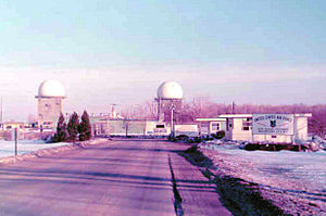
Watertown Air Force Station
| Watertown Air Force Station | |
|---|---|
| Part of 1951-1968: 1968-1979: 1979-1984: |
|
| Watertown, New York | |

2 radomes and the main gate with guard shack (1975)
|
|
| Coordinates | 43°55′31″N 075°54′33″W / 43.92528°N 75.90917°W |
| Type | Long Range Radar Site |
| Code | RP-49: 1950 ADC permanent network Z-49: 1963 July 31 NORAD network |
| Site information | |
| Controlled by |
|
| Site history | |
| Built | 1952 |
| Built by | U.S. Air Force |
| In use | 1952-1979 |
| Garrison information | |
| Garrison | Watertown, New York |
| Occupants | 655th Radar Squadron |
Watertown Air Force Station is a closed United States Air Force ADCOM General Surveillance Radar station 3.5 miles (5.6 km) south of Watertown, New York. Prior to the Air Defense squadron inactivating on 1 November 1979, the station was reassigned to Tactical Air Command which maintained the Ground Air Transmitter Receiver until early 1984 (now a firefighter training site). A New York State jail opened at the site c. 1983.
It was a part of the 21st RCC (NORAD Regional Control Center) a SAGE network, located at Stewart AFB.
Lashup Radar Network site L-6 was established in June 1950 at the Pine Camp military installation (renamed Fort Drum in 1951) and operated by the 655th Aircraft Control and Warning Squadron using an RCA AN/TPS-10A Radar. After construction adjacent to Fort Drum in June 1952, the operation moved to the Air Force Station, one of the first twenty-four Air Defense Command radar stations of the permanent network established 1950-1951 after the USAF directed construction of the sites in December 2, 1948. Watertown AFS used AN/FPS-3 and AN/FPS-5 radars for warning and ground-controlled interception. In 1958 this site was operating with AN/FPS-20 search radar and General Electric AN/FPS-6 Radar for height-finding.
...
Wikipedia
