Waterland
| Waterland | |||
|---|---|---|---|
| Municipality | |||

Marken town centre
|
|||
|
|||
 Location in North Holland |
|||
| Coordinates: 52°27′N 5°2′E / 52.450°N 5.033°ECoordinates: 52°27′N 5°2′E / 52.450°N 5.033°E | |||
| Country | Netherlands | ||
| Province | North Holland | ||
| Established | 1 January 1991 | ||
| Government | |||
| • Body | Municipal council | ||
| • Mayor | Luzette Wagenaar-Kroon (CDA) | ||
| Area | |||
| • Total | 115.66 km2 (44.66 sq mi) | ||
| • Land | 52.11 km2 (20.12 sq mi) | ||
| • Water | 63.55 km2 (24.54 sq mi) | ||
| Elevation | −1 m (−3 ft) | ||
| Population (May 2014) | |||
| • Total | 17,164 | ||
| • Density | 329/km2 (850/sq mi) | ||
| Demonym(s) | Waterlander | ||
| Time zone | CET (UTC+1) | ||
| • Summer (DST) | CEST (UTC+2) | ||
| Postcode | 1140–1156, 1452–1454 | ||
| Area code | 0299 | ||
| Website | www |
||
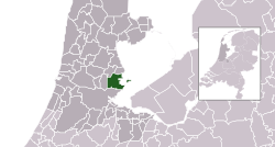
Waterland (![]() pronunciation ) is a municipality in the Netherlands, in the province of North Holland. It is located north of Amsterdam, on the western shore of the Markermeer.
pronunciation ) is a municipality in the Netherlands, in the province of North Holland. It is located north of Amsterdam, on the western shore of the Markermeer.
The municipality of Waterland consists of the following cities, towns, villages and/or districts: Broek in Waterland, Ilpendam, Katwoude, Marken, Monnickendam, Overleek, Uitdam, Watergang, Zuiderwoude.
Dutch Topographic map of the municipality of Waterland, 2013.
The municipal council of Waterland consists (2002) of 17 seats, which are divided as follows:
...
Wikipedia


