Wasta, South Dakota
|
Wasta, South Dakota wašté |
|
|---|---|
| Town | |

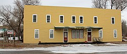
The Wasta Hotel, located at Ash and B streets in Wasta. The hotel is listed on the National Register of Historic Places.
|
|
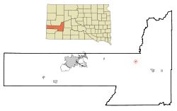
 Location in Pennington County and the state of South Dakota |
|
| Coordinates: 44°4′7″N 102°26′42″W / 44.06861°N 102.44500°WCoordinates: 44°4′7″N 102°26′42″W / 44.06861°N 102.44500°W | |
| Country | United States |
| State | South Dakota |
| County | Pennington |
| Incorporated | 1930 |
| Area | |
| • Total | 0.19 sq mi (0.49 km2) |
| • Land | 0.19 sq mi (0.49 km2) |
| • Water | 0 sq mi (0 km2) |
| Elevation | 2,320 ft (707 m) |
| Population (2010) | |
| • Total | 80 |
| • Estimate (2012) | 81 |
| • Density | 421.1/sq mi (162.6/km2) |
| Time zone | Mountain (MST) (UTC-7) |
| • Summer (DST) | MDT (UTC-6) |
| ZIP codes | 57767, 57791 |
| Area code(s) | 605 |
| FIPS code | 46-69140 |
| GNIS feature ID | 1258837 |
Wasta (Lakota: 'wašté') is a town in Pennington County, South Dakota, United States along the Cheyenne River. The population was 80 at the 2010 census.
A post office called Wasta has been in operation since 1907. Wasta is a name derived from the Dakota word "wašté", meaning "good".
Wasta is located at 44°4′7″N 102°26′42″W / 44.06861°N 102.44500°W (44.068638, -102.445108).
According to the United States Census Bureau, the town has a total area of 0.19 square miles (0.49 km2), all of it land.
Wasta has been assigned the ZIP code 57791 and the FIPS place code 69140.
As of the census of 2010, there were 80 people, 36 households, and 20 families residing in the town. The population density was 421.1 inhabitants per square mile (162.6/km2). There were 46 housing units at an average density of 242.1 per square mile (93.5/km2). The racial makeup of the town was 100.0% White. Hispanic or Latino of any race were 1.3% of the population.
...
Wikipedia
