Washington State Route 16
| State Route 16 | ||||
|---|---|---|---|---|

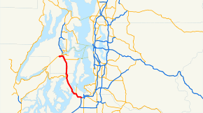
SR 16 is highlighted in red.
|
||||
| Route information | ||||
| Defined by RCW 47.17.065 | ||||
| Maintained by WSDOT | ||||
| Length: | 27.16 mi (43.71 km) | |||
| Existed: | 1964 – present | |||
| Major junctions | ||||
| East end: |
|
|||
|
|
||||
| West end: |
|
|||
| Location | ||||
| Counties: | Pierce, Kitsap | |||
| Highway system | ||||
|
||||
|
State Route 16 Spur |
|
|---|---|
| Location: | Gorst, Washington |
| Length: | 0.39 mi (0.63 km) |
| Existed: | 1988–present |
|
State Route 16 Alternate |
|
|---|---|
| Location: | Tacoma Narrows Bridge |
| Length: | 0.68 mi (1.09 km) |
| Existed: | 2007–present |
State Route 16 (SR 16) is a 27.16-mile-long (43.71 km) state highway in the U.S. state of Washington, connecting Pierce and Kitsap counties. The highway, signed as east–west, begins at an interchange with Interstate 5 (I-5) in Tacoma and travels through the city as a freeway towards the Tacoma Narrows. SR 16 crosses the narrows onto the Kitsap Peninsula on the partially tolled Tacoma Narrows Bridge and continues through Gig Harbor and Port Orchard before the freeway ends in Gorst. The designation ends at an intersection with SR 3 southwest of the beginning of its freeway through Bremerton and Poulsbo. SR 16 is designated as a Strategic Highway Network (STRAHNET) corridor within the National Highway System as the main thoroughfare connecting Tacoma to Naval Base Kitsap and a part of the Highways of Statewide Significance program.
...
Wikipedia

