Washington Grove, MD
| Washington Grove, Maryland | |
|---|---|
| Town | |
| Town of Washington Grove | |

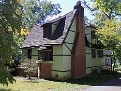
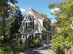
The Washington Grove Historic District in September 2012.
|
|
| Motto: "A Town Within a Forest" | |
 Location of Washington Grove, Maryland |
|
| Coordinates: 39°8′22″N 77°10′33″W / 39.13944°N 77.17583°WCoordinates: 39°8′22″N 77°10′33″W / 39.13944°N 77.17583°W | |
| Country | |
| State |
|
| County |
|
| Founded | July 29, 1874 |
| Incorporated | March 26, 1937 |
| Government | |
| • Mayor | Joli A. McCathran |
| Area | |
| • Total | 0.35 sq mi (0.91 km2) |
| • Land | 0.35 sq mi (0.91 km2) |
| • Water | 0 sq mi (0 km2) |
| Elevation | 509 ft (155 m) |
| Population (2010) | |
| • Total | 555 |
| • Estimate (2016) | 564 |
| • Density | 1,600/sq mi (610/km2) |
| Time zone | Eastern (EST) (UTC-5) |
| • Summer (DST) | EDT (UTC-4) |
| ZIP code | 20880 |
| Area code(s) | 301, 240 |
| FIPS code | 24-81675 |
| GNIS feature ID | 0591497 |
| Website | http://www.washingtongrovemd.org/ |
|
Washington Grove Historic District
|
|

The Washington Grove Historic District, in September 2012.
|
|
| Location | Washington Grove, Maryland |
|---|---|
| Coordinates | 39°8′24″N 77°10′28″W / 39.14000°N 77.17444°W |
| Built | 1873 |
| Architect | Unknown |
| Architectural style | Late Gothic Revival, Other |
| NRHP reference # | 80001829 |
| Added to NRHP | April 09, 1980 |
Washington Grove is a town in Montgomery County, Maryland. The population was 555 at the 2010 United States Census. The Washington Grove Historic District was listed on the National Register of Historic Places in 1980.
Around 1800 Methodists began the tradition of camp meetings, where a group of Methodists would gather in a forest clearing to worship. Benches were arranged in a circle or oval with an elevated preachers' stand in the middle. Tents surrounded the area along with carriages and wagons behind them. Services lasted well into the night. The camp meetings provided cultural and spiritual improvement to those who attended.
In 1873 a committee from the Foundry Methodist Church, located at 14th and G streets NW in Washington, D.C., began a search for a permanent location to hold annual camp meetings. They wanted a location with sufficient space for thousands of attendees, a supply of clean water, and a shaded location to provide relief from the summer sun. They wanted the location to be less than a day's trip from Washington, D.C., and protection from the sale of liquor, because Methodists did not believe in drinking alcohol.
In June 1873 John T. Mitchell, Richard Willett, F. Howard, W.R. Woodward, E.F. Simpson, Mr. Worthington, Thomas P. Morgan, B. Peyton Brown, and a few others purchased 267.5 acres (1.1 km2) of land from the widow of farmer Nathan Cooke for $6,636.25. The land was given to the newly incorporated Washington Grove Meeting Association.
A person could build a cottage on the land by purchasing five shares of stock for twenty dollars per share. The first share had to be purchased with cash, while the other four could be financed at an annual interest rate of six percent. Alternatively, a tent could be rented for between $9 and $15. There were two dining courts, and a market would provided fresh meat and produce. The center of the camp was originally named The Plaza and later The Symbolic Circle, and there were six numbered avenues radiating from it. Tents were arranged in a grid along avenues named for participating churches. Families would stay over to attend a two-week-long meeting of the Methodist Episcopal churches of the District of Columbia. Named Washington Grove Camp, the first camp meeting began on August 5, 1874, with 240 tents.
...
Wikipedia


