Washington County, Idaho
| Washington County, Idaho | ||
|---|---|---|

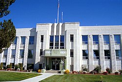
Washington County Courthouse in Weiser
|
||
|
||
 Location in the U.S. state of Idaho |
||
 Idaho's location in the U.S. |
||
| Founded | February 20, 1879 | |
| Named for | George Washington | |
| Seat | Weiser | |
| Largest city | Weiser | |
| Area | ||
| • Total | 1,474 sq mi (3,818 km2) | |
| • Land | 1,453 sq mi (3,763 km2) | |
| • Water | 21 sq mi (54 km2), 1.4% | |
| Population (est.) | ||
| • (2015) | 9,984 | |
| • Density | 7.0/sq mi (3/km²) | |
| Congressional district | 1st | |
| Time zone | Mountain: UTC-7/-6 | |
| Website | www |
|
Washington County is a county in the U.S. state of Idaho. As of the 2010 census, the population was 10,198. The county seat and largest city is Weiser, with over half of the county's population. The county was established in 1879 when Idaho was a territory and named after U.S. president George Washington.
Washington County is home to the Idaho ground squirrel.
According to the U.S. Census Bureau, the county has a total area of 1,474 square miles (3,820 km2), of which 1,453 square miles (3,760 km2) is land and 21 square miles (54 km2) (1.4%) is water.
As of the census of 2000, there were 9,977 people, 3,762 households, and 2,738 families residing in the county. The population density was 7 people per square mile (3/km²). There were 4,138 housing units at an average density of 3 per square mile (1/km²). The racial makeup of the county was 87.61% White, 1.03% Asian, 0.66% Native American, 0.10% Black or African American, 0.07% Pacific Islander, 8.17% from other races, and 2.36% from two or more races. 13.75% of the population were Hispanic or Latino of any race. 15.7% were of German, 14.3% English, 10.1% American and 7.7% Irish ancestry according to Census 2000.
...
Wikipedia

