Washington, Virginia
| Washington, Virginia | |
|---|---|
| Town | |

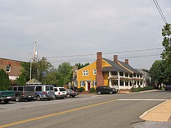
Central intersection in Washington
|
|
 Location of Washington, Virginia |
|
| Coordinates: 38°42′46″N 78°9′34″W / 38.71278°N 78.15944°WCoordinates: 38°42′46″N 78°9′34″W / 38.71278°N 78.15944°W | |
| Country | United States |
| State | Virginia |
| County | Rappahannock |
| Named for | George Washington |
| Area | |
| • Total | 0.3 sq mi (0.7 km2) |
| • Land | 0.3 sq mi (0.7 km2) |
| • Water | 0.0 sq mi (0.0 km2) |
| Elevation | 682 ft (208 m) |
| Population (2010) | |
| • Total | 135 |
| Time zone | Eastern (EST) (UTC-5) |
| • Summer (DST) | EDT (UTC-4) |
| ZIP code | 22747 |
| Area code(s) | 540 |
| FIPS code | 51-83248 |
| GNIS feature ID | 1500280 |
Washington is a town in and the county seat of Rappahannock County, Virginia, United States. The site of this town was surveyed by George Washington himself in July 1749. It was the first of what would be many American places to be named after the future first president. Its population was just 135 people at the 2010 census, down from 183 in the 2000 census. It is nicknamed Little Washington to avoid confusion because of its proximity to Washington, D.C., which lies only 70 miles (110 km) to the north east.
The Town of Washington was formerly the location of a trading post utilized by frontier families and members of the resident Manahoac tribe. All of the territory in and around the current town was under the ownership of Thomas Fairfax, 6th Lord Fairfax of Cameron. In 1748, Lord Fairfax met a 16-year-old George Washington, a distant relative of his. Being impressed by his character, Fairfax employed Washington to survey his lands west of the Blue Ridge Mountains. On July 24, 1749, the town layout as it appears today was surveyed and platted by Washington with the assistance of his chainmen John Lonem and Edward Corder as part of his service to Fairfax. The village was officially established as a Town by the Virginia General Assembly on December 14, 1795 when it gained the requisite population of 200. Records from an 1835 gazetteer state that the town contained one academy, fifty-five dwellings, four mercantile stores, two taverns, one house of worship, twenty-seven trade shops, and two large flour mills.
During the Civil War, a home on the town's Main Street served as a Confederate Hospital. In the late 19th century when rail became the main method of trade, the main east-west railway route of the time was constructed north of town through the accessible Thoroughfare Gap. Washington was relatively unaffected by the Industrial Age and thus the current town is quite similar to the one of 150 years ago. By the start of the 20th century the population reached three hundred, supporting businesses such as three garages and a barber shop. However, since then, the population had declined to less than 200.
...
Wikipedia
