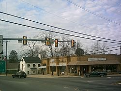
Warsaw, Virginia
| Warsaw, Virginia | |
|---|---|
| Town | |

Shops in central Warsaw
|
|
 Location of Warsaw, Virginia |
|
| Coordinates: 37°57′27″N 76°45′30″W / 37.95750°N 76.75833°WCoordinates: 37°57′27″N 76°45′30″W / 37.95750°N 76.75833°W | |
| Country | United States |
| State | Virginia |
| County | Richmond |
| Government | |
| • Mayor | Randy L. Phelps |
| Area | |
| • Total | 3.0 sq mi (7.9 km2) |
| • Land | 3.0 sq mi (7.9 km2) |
| • Water | 0.0 sq mi (0.0 km2) |
| Elevation | 131 ft (40 m) |
| Population (2010) | |
| • Total | 1,512 |
| • Density | 453.0/sq mi (174.9/km2) |
| Time zone | Eastern (EST) (UTC-5) |
| • Summer (DST) | EDT (UTC-4) |
| ZIP code | 22572 |
| Area code(s) | 804 |
| FIPS code | 51-83168 |
| GNIS feature ID | 1500279 |
Warsaw is a town in and the county seat of Richmond County, Virginia, United States. The population was 1,512 at the 2010 census.
The original name of the town was Richmond Courthouse. In 1831 the town's name was changed to Warsaw, after the news of the bloody Battle of Warsaw reached local residents. A number of other small towns in the United States changed their names to Warsaw at this time (Warsaw, Kentucky for instance), all as a result of sympathy in the United States for the November Uprising in Poland. Because Richmond Courthouse was still unincorporated in 1830, it is unclear who was responsible for the change of name to Warsaw. Historic sites nearby include Menokin, the former home of Francis Lightfoot Lee, Mount Airy and Sabine Hall. A former plantation estate Belle Mount is currently operated as a vineyard and winery within a few miles of Warsaw town limits.
In addition to Menokin, Mounty Airy, and Sabine Hall, Grove Mount and the Richmond County Courthouse are listed on the National Register of Historic Places. The formerly listed Bladensfield was destroyed by fire in 1996.
Warsaw is located at 37°57′27″N 76°45′30″W / 37.95750°N 76.75833°W (37.957617, −76.758302).
...
Wikipedia
