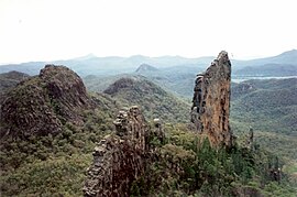
Warrumbungles National Park
|
Warrumbungle National Park New South Wales |
|
|---|---|
|
IUCN category II (national park)
|
|

|
|
| Nearest town or city | Coonabarabran |
| Coordinates | 31°17′32″S 149°00′29″E / 31.29222°S 149.00806°ECoordinates: 31°17′32″S 149°00′29″E / 31.29222°S 149.00806°E |
| Area | 233.11 km2 (90.0 sq mi) |
| Visitation | 35,000 (in 2011) |
| Managing authorities | National Parks and Wildlife Service (New South Wales) |
| Website | Warrumbungle National Park |
| See also | Protected areas of New South Wales |
Warrumbungle National Park is a heritage listed national park located in the Orana region of New South Wales, Australia. The national park is located approximately 550 kilometres (340 mi) northwest of Sydney and contained within 23,311 hectares (57,600 acres). The park attracts approximately 35,000 visitors per annum.
The national park is based on the geographical Warrumbungle Mountain Range, sometimes shortened to the Warrumbungles, and thus the park name is often heard in the plural. The comic strip Warrumbunglers may also have played some part in this usage. The park lies within the Pilliga Important Bird Area, so identified by BirdLife International because of its importance for a range of woodland bird species, many of which are threatened.
Warrumbungle National Park was added to the Australian National Heritage List in December 2006.
On 4 July 2016, the park was the first within Australia to be certified as a Dark Sky Park by the International Dark Sky Association.
The nearest towns to the park are Baradine, Coonabarabran, Coonamble, Gilgandra, Gulargambone, and Tooraweenah. Access via Coonabarabran to the east is by 27 kilometres (17 mi) of sealed road called the John Renshaw Parkway, built in 1966. Via Coonamble to the west, access is by a 57 kilometres (35 mi) long road with some gravel.
...
Wikipedia

