Warren County, Pennsylvania
| Warren County, Pennsylvania | |
|---|---|

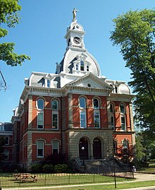
Warren County Courthouse
|
|
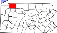
 Location in the U.S. state of Pennsylvania |
|
 Pennsylvania's location in the U.S. |
|
| Founded | October 1, 1819 |
| Seat | Warren |
| Largest city | Warren |
| Area | |
| • Total | 899 sq mi (2,328 km2) |
| • Land | 884 sq mi (2,290 km2) |
| • Water | 14 sq mi (36 km2), 1.6% |
| Population (est.) | |
| • (2015) | 40,396 |
| • Density | 46/sq mi (18/km²) |
| Congressional district | 5th |
| Time zone | Eastern: UTC-5/-4 |
| Website | www |
Warren County is a county located in the U.S. state of Pennsylvania. As of the 2010 census, the population was 41,815. Its county seat is Warren. The county was formed in 1800 from parts of Allegheny and Lycoming counties; attached to Crawford County until 1805 and then to Venango County until Warren was formally organized in 1819.
Warren County makes up the Warren, PA Micropolitan Statistical Area.
According to the U.S. Census Bureau, the county has a total area of 899 square miles (2,330 km2), of which 884 square miles (2,290 km2) is land and 14 square miles (36 km2) (1.6%) is water. Notable physical features include the Allegheny River, the Allegheny Reservoir, the Kinzua Dam, and the Allegheny National Forest.
As of the census of 2000, there were 43,863 people, 17,696 households, and 12,121 families residing in the county. The population density was 50 people per square mile (19/km²). There were 23,058 housing units at an average density of 26 per square mile (10/km²). The racial makeup of the county was 98.68% White, 0.21% Black or African American, 0.19% Native American, 0.27% Asian, 0.02% Pacific Islander, 0.12% from other races, and 0.52% from two or more races. 0.34% of the population were Hispanic or Latino of any race. 22.2% were of German, 12.4% Swedish, 11.2% American, 10.5% Irish, 8.8% English, 8.2% Italian and 5.1% Polish ancestry according to Census 2000.
...
Wikipedia
