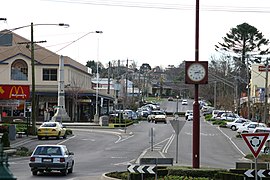
Warragul
|
Warragul Victoria |
|||||||||||||
|---|---|---|---|---|---|---|---|---|---|---|---|---|---|
 |
|||||||||||||
| Coordinates | 38°9′0″S 145°56′0″E / 38.15000°S 145.93333°ECoordinates: 38°9′0″S 145°56′0″E / 38.15000°S 145.93333°E | ||||||||||||
| Population | 16,700 (2011 census) | ||||||||||||
| Postcode(s) | 3820 | ||||||||||||
| Elevation | 143 m (469 ft) | ||||||||||||
| Location | |||||||||||||
| LGA(s) | Shire of Baw Baw | ||||||||||||
| County | Buln Buln | ||||||||||||
| State electorate(s) | Narracan | ||||||||||||
| Federal Division(s) | McMillan | ||||||||||||
|
|||||||||||||
|
|||||||||||||
Warragul is a town in Victoria, Australia, 104 kilometres (65 mi) east-southeast of Melbourne. Warragul lies between the Strzelecki Ranges to the south and the Mount Baw Baw Plateau of the Great Dividing Range to the north. The town is named after an Aboriginal word meaning "wild dog". As at the 2011 census, the town had a population of 14,074 people. Warragul forms part of a larger urban area that includes nearby Drouin that had an estimated population of 33,386 at June 2015.
Warragul is the main population and service centre of the West Gippsland region and the Shire of Baw Baw. The surrounding area is noted for dairy farming and other niche agriculture and has long been producing gourmet foods.
Warragul was settled after the construction of the Traralgon railway line in 1877, the Post Office opening on 16 March 1877.
Existing roads were renamed Princes Highway after the visit to Australia in 1920 of the then Prince of Wales (the future King Edward VIII). The highway was officially opened on 10 August 1920 at a ceremony in Warragul.
Warragul's Petersville Milk Products Factory in Queen Street supplied the famous Peters Ice Cream brand's factory in Mulgrave with all the dairy raw material (fresh cream and concentrated skim milk) for 35 years. The plant also manufactured skim milk powder under the famous Dutch Jug brand and butter under the Iceberg brand. It exported butter, butter oil and milk powders to Southeast Asia and the Middle East.
Warragul (along with Drouin), is located on a lobe of hills that extend north from the Strzelecki Ranges near Ellinbank, joining the foothills of the Baw Baws in the Neerim District. This range is historically referred to as the Warragul Hills. The range effectively separates the flatlands of the Koo Wee Rup swamp (starting near Longwarry) in the west and the Moe Swamp on the eastern side (starting near Darnum).
...
Wikipedia

