Ware River
| Ware River | |
|---|---|

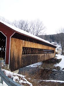
Covered Bridge in Gilbertville
|
|
| Basin features | |
| Main source |
Hubbardston 830 feet (250 m) 42°28′19″N 71°59′56″W / 42.472°N 71.999°W |
| River mouth |
Three Rivers 290 feet (88 m) 42°10′51″N 72°21′55″W / 42.1807°N 72.3654°WCoordinates: 42°10′51″N 72°21′55″W / 42.1807°N 72.3654°W |
| Basin size | 96 square miles (250 km2) |
| Physical characteristics | |
| Length | 35.4 miles (57.0 km) |
| Discharge |
|
The Ware River is a 35.4-mile-long (57.0 km) river in central Massachusetts. It has two forks, the longest of which (the east branch) begins near Hubbardston, Massachusetts. The Ware River flows southwest through the middle of the state, joins the Quaboag River at Three Rivers, Massachusetts, to form the Chicopee River on its way to the Connecticut River.
The Brigham Pond Dam, forming a pond of the same name, first impounds the East Branch of the Ware River in Westminster. The area north of Hubbardston feeds tributaries of the Ware and Millers rivers, the Millers River running generally west, and the Ware River running generally southwest. The Ware River is part of the Massachusetts Water Resources Authority drinking water system serving the greater Boston area.
The river was named for early fish weirs (locally pronounced). In 1928 the building of a 12.5-mile-long (20.1 km) aqueduct connecting the Ware River to the Wachusett Reservoir commenced a major public works undertaking. The 12-foot-wide (3.7 m) massive horseshoe-shaped conduit, known as the Wachusett-Coldbrook Tunnel, had to be blasted through solid rock at a depth of 200 feet (60 m). The arrival in 1931 of the first water from the Ware River by way of this tunnel probably saved the Wachusett Reservoir from drying up, for a prolonged drought had reduced Wachusett’s water supply to less than 20 percent of capacity.
In 1933 the Quabbin Aqueduct was completed, ready to transport water from the Quabbin Reservoir under construction. The Swift River Diversion tunnel is in full use, bypassing water around the dam area.
The Ware River starts at an elevation of about 830 feet (250 m) above sea level, fed from the numerous small streams within its watershed, before ending at the village of Three Rivers at an elevation of about 290 feet (88 m). The river flows through many historic mill towns where its fall towards the sea provided power. One of the largest such towns is Ware, Massachusetts, which shares its name. This river is part of the Chicopee River Watershed.
...
Wikipedia
