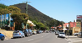
Warburton, Victoria
|
Warburton Victoria |
|||||||||||||
|---|---|---|---|---|---|---|---|---|---|---|---|---|---|

Main Street, Warburton
|
|||||||||||||
| Coordinates | 37°45′18″S 145°41′49″E / 37.755°S 145.697°ECoordinates: 37°45′18″S 145°41′49″E / 37.755°S 145.697°E | ||||||||||||
| Population | 2,171 (2011 census) | ||||||||||||
| Postcode(s) | 3799 | ||||||||||||
| Elevation | 159 m (522 ft) | ||||||||||||
| Location | 72 km (45 mi) from Melbourne | ||||||||||||
| LGA(s) | Shire of Yarra Ranges | ||||||||||||
| State electorate(s) | Eildon | ||||||||||||
| Federal Division(s) | McEwen | ||||||||||||
|
|||||||||||||
Warburton is a town in Victoria, Australia, 72 kilometres east of Melbourne's central business district. Its local government area is the Shire of Yarra Ranges. At the 2011 census, Warburton had a population of 2,171.
The name "Warburton" has been shared between two townships over the years. The mining town of "Yankee Jim's Creek" was located on the gold-bearing slopes of Mount Little Joe. Hostile terrain, fire, drought, flood, steep slopes, unsustainable roads, crime and easier pickings for miners further upstream put an end to "Old Warburton". Land was surveyed and sold in the valley below in 1884 (1884 Selections (on the Upper Yarra), Woori-Yallock and Warburton, County of Evelyn [cartographic material] lithographed at the Department of Lands and Survey, Melbourne by W. J. Folwarczny, 2.4.1884.Melbourne:Dept. of Lands and Survey, State Library of Victoria)
The Post Office opened around 1884. Two earlier offices named Warburton were renamed as Launching Place and Hoddle's Creek.
Warburton was connected to Lilydale by a Victorian Railways branch line, which was closed in 1965. The railway path is now used for the Lilydale to Warburton Rail Trail, a rail trail used by pedestrians, cyclists, and horse-riders.
East of Warburton is a large water catchment area called Upper Yarra Dam, which is designed to supply Melbourne with water sourced from the Thomson catchment area. Robert Hoddle first surveyed this area in 1845 after persistent overwhelming floods impounded development for the city of Melbourne.
Together with its neighbouring township Millgrove, Warburton has an Australian Rules football team (Warburton Millgrove) competing in the Yarra Valley Mountain District Football League.
...
Wikipedia

