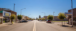
Wapato, Washington
| Wapato, Washington | |
|---|---|
| City | |

Wapato Avenue
|
|
 Location of Wapato, Washington |
|
| Location in the United States | |
| Coordinates: 46°26′44″N 120°25′19″W / 46.44556°N 120.42194°WCoordinates: 46°26′44″N 120°25′19″W / 46.44556°N 120.42194°W | |
| Country | United States |
| State | Washington |
| County | Yakima |
| Area | |
| • Total | 1.17 sq mi (3.03 km2) |
| • Land | 1.17 sq mi (3.03 km2) |
| • Water | 0 sq mi (0 km2) |
| Elevation | 856 ft (261 m) |
| Population (2010) | |
| • Total | 4,997 |
| • Estimate (2015) | 5,068 |
| • Density | 4,270.9/sq mi (1,649.0/km2) |
| Time zone | Pacific (PST) (UTC-8) |
| • Summer (DST) | PDT (UTC-7) |
| ZIP code | 98951 |
| Area code | 509 |
| FIPS code | 53-76125 |
| GNIS feature ID | 1512774 |
| Website | City of Wapato |
Wapato is a city in Yakima County, Washington, United States. The population was 4,997 at the 2010 census.
The town was founded in 1885 by Indian Postmaster Alexander McCredy as a railroad stop on the Northern Pacific Railroad as Simcoe, Washington. The Dawes Severalty Act of 1887 made it legal for the Yakama Indian Nation to sell their lands, and began to draw settlers into the area. With the construction of the Irwin Canal in 1896, agriculture became the big business in town. In the early 1900s, McCredy and George Rankin established the Wapato Development Company and laid out the town site. They established the town's first bank and began selling lots. In response to persistent confusion with nearby Fort Simcoe, the town changed its name to Wapato in 1903. The 1906 Jones Act further encouraged Anglos to purchase land from the Yakamas. Wapato was officially incorporated on September 16, 1908 with a population of around 300 people.
As early as 1905, many Japanese people also began to migrate to the city, mainly from Hawaii. From 1916 to 1918, "Japanese Town" developed along present-day West 2nd Street. With more than 1000 Japanese then living in the Yakima Valley, the community soon became a center of Washington's Japanese population, second only to Seattle. The Yakima Buddhist Bussei Kaikan (1936–1941), on West 2nd Street, was an architecturally noteworthy building built by members of the congregation. Unfortunately it was not to last, as Roosevelt's Executive Order 9066 forced the Japanese to evacuate from Wapato in 1942, many residents headed for internment camps.
During World War II, much of the labor in the orchards and fields around Wapato came from either Germans held in a POW camp between Wapato and Toppenish, or from Japanese still being held in internment camps. At the end of the war, a labor shortage created a void readily filled by Hispanic migrant workers, and the Bracero Program (a guest-worker program agreed to by the US and Mexico during World War II). These events significantly changed Wapato's cultural history.
...
Wikipedia

