Wantage, New Jersey
| Wantage Township, New Jersey | |
|---|---|
| Township | |
| Township of Wantage | |

|
|
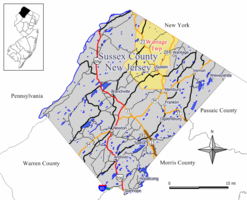
 Map of Wantage Township in Sussex County. Inset: Location of Sussex County highlighted in the State of New Jersey. |
|
 Census Bureau map of Wantage Township, New Jersey. |
|
| Coordinates: 41°15′08″N 74°37′58″W / 41.252181°N 74.632827°WCoordinates: 41°15′08″N 74°37′58″W / 41.252181°N 74.632827°W | |
| Country |
|
| State |
|
| County | Sussex |
| Formed | May 30, 1754 (as precinct) |
| Incorporated | February 21, 1798 |
| Named for | Wantage, England |
| Government | |
| • Type | Township |
| • Body | Township Committee |
| • Mayor | Ronald Bassani (R, term ends December 31, 2016) |
| • Administrator / Clerk | James Doherty |
| Area | |
| • Total | 67.481 sq mi (174.776 km2) |
| • Land | 66.753 sq mi (172.890 km2) |
| • Water | 0.728 sq mi (1.886 km2) 1.08% |
| Area rank | 18th of 566 in state 2nd of 24 in county |
| Elevation | 538 ft (164 m) |
| Population (2010 Census) | |
| • Total | 11,358 |
| • Estimate (2015) | 11,074 |
| • Rank | 215th of 566 in state 4th of 24 in county |
| • Density | 170.1/sq mi (65.7/km2) |
| • Density rank | 518th of 566 in state 18th of 24 in county |
| Time zone | Eastern (EST) (UTC-5) |
| • Summer (DST) | Eastern (EDT) (UTC-4) |
| ZIP code | 07461 |
| Area code(s) | 973 |
| FIPS code | 3403776790 |
| GNIS feature ID | 0882257 |
| Website | www |
Wantage Township is a township in Sussex County, New Jersey, United States. As of the 2010 United States Census, the township's population was 11,358, reflecting an increase of 971 (+9.3%) from the 10,387 counted in the 2000 Census, which had in turn increased by 900 (+9.5%) from the 9,487 counted in the 1990 Census.
Wantage Township was formed as a precinct on May 30, 1754, from portions of Newton Township. It was incorporated as a Township on February 21, 1798, as part of the state's initial group of 104 townships. Boundary exchanges were made with Frankford Township in both 1826 and 1834. Portions of the township were taken on October 14, 1891, to form the Borough of Deckertown (which was renamed to Sussex borough in 1902). The township was named for Wantage, England.
According to the United States Census Bureau, the township had a total area of 67.481 square miles (174.776 km2), including 66.753 square miles (172.890 km2) of land and 0.728 square miles (1.886 km2) of water (1.08%). The township is located in the Kittatinny Valley which is a section of the Great Appalachian Valley that stretches for 700 miles (1,100 km) from Canada to Alabama.
Unincorporated communities, localities and place names located partially or completely within the township include Beemerville, Colesville, Hanford, Lake Neepaulin, Lake Rutherford, Lewisburg, Libertyville, Martins, Mount Salem, Papakating, Plumbsock, Quarryville, Rockport, Roys and Woodbourne.
...
Wikipedia
