Wanborough, Wiltshire
| Wanborough | |
|---|---|
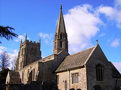
 St Andrew's parish church |
|
| Wanborough shown within Wiltshire | |
| Population | 2,069 (in 2011) |
| OS grid reference | SU2082 |
| Civil parish |
|
| Unitary authority | |
| Ceremonial county | |
| Region | |
| Country | England |
| Sovereign state | United Kingdom |
| Post town | Swindon |
| Postcode district | SN4 |
| Dialling code | 01793 |
| Police | Wiltshire |
| Fire | Dorset and Wiltshire |
| Ambulance | South Western |
| EU Parliament | South West England |
| UK Parliament | |
| Website | Parish Council |
Wanborough is a large village and civil parish in the borough of Swindon, Wiltshire, England. The village is about 3.5 miles (5.6 km) southeast of Swindon town centre. The settlement along the High Street is Lower Wanborough, while Upper Wanborough is on higher ground to the southwest. The parish includes the hamlets of Horpit (a short distance north of Wanborough) and Foxhill, 1.5 miles (2.4 km) to the southeast.
There was a Roman settlement, Durocornovium, slightly northwest of the current village, at a road junction mentioned in the Antonine Itinerary. Being the last vicus on Ermin Way or Ermin Street before the scarp slope of the Marlborough Downs, Durocornovium was a site where horses were watered before the steep climb off the Oxfordshire plain.
Wanborough was recorded in the Anglo-Saxon Chronicle as Wôdnes-beorg which later became Wodnesborough before becoming Wanborough.
Wanborough is just off the Ridgeway National Trail. Development in a strip along the road frontages characterised the village, which reached maximum development in the 4th century.
The Church of England parish church of Saint Andrew is unusual in having a spire at one end and a tower at the other. There are only three parish churches with this feature in the UK. The others are at nearby Purton and at Ormskirk, Lancashire.
...
Wikipedia

