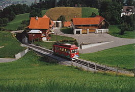
Walzenhausen, Switzerland
| Walzenhausen | ||
|---|---|---|
 |
||
|
||
| Coordinates: 47°27′N 9°36′E / 47.450°N 9.600°ECoordinates: 47°27′N 9°36′E / 47.450°N 9.600°E | ||
| Country | Switzerland | |
| Canton | Appenzell Ausserrhoden | |
| District | n.a. | |
| Area | ||
| • Total | 7.0 km2 (2.7 sq mi) | |
| Elevation | 672 m (2,205 ft) | |
| Population (Dec 2016) | ||
| • Total | 2,034 | |
| • Density | 290/km2 (750/sq mi) | |
| Postal code | 9428 | |
| SFOS number | 3037 | |
| Surrounded by | Au (SG), Berneck (SG), Lutzenberg, Oberegg (AI), Rheineck (SG), Sankt Margrethen (SG), Wolfhalden | |
| Website |
www SFSO statistics |
|
Walzenhausen is a municipality in the canton of Appenzell Ausserrhoden in Switzerland.
The farm Walzenhausen was mentioned first in 1320. The church was built in 1638 in as little as nine months. This was the establishment of Walzenhausen as a municipality.
In the past textiles played an important role, but today tourism has taken this role. This is facilitated by good public transport links.
Walzenhausen has an area, as of 2006[update], of 7 km2 (2.7 sq mi). Of this area, 52.4% is used for agricultural purposes, while 34.4% is forested. The rest of the land, (13.1%) is settled.
Walzenhausen is the eastern most village in the canton Appenzell Ausserrhoden. It lies at 670 m (2,200 ft) and offers a panorama of Lake Constance 300 m (980 ft) below.
The Rheineck–Walzenhausen mountain railway links the village to Rheineck railway station, 272 m (892 ft) below. The line operates one or two return journeys per hour, depending on the time of day, which connect at Rheineck with main line services to the city of St. Gallen and other local towns. Local buses link Walzenhausen to Heiden and St. Margrethen.
Walzenhausen has a population (as of 2008[update]) of 2,071, of which about 16.2% are foreign nationals. Over the last 10 years the population has decreased at a rate of -4.1%. Most of the population (as of 2000[update]) speaks German (92.3%), with Serbo-Croatian being second most common ( 1.7%) and Italian being third ( 1.4%).
...
Wikipedia


