Wolfhalden
| Wolfhalden | ||
|---|---|---|
 |
||
|
||
| Coordinates: 47°27′N 9°33′E / 47.450°N 9.550°ECoordinates: 47°27′N 9°33′E / 47.450°N 9.550°E | ||
| Country | Switzerland | |
| Canton | Appenzell Ausserrhoden | |
| District | n.a. | |
| Area | ||
| • Total | 6.95 km2 (2.68 sq mi) | |
| Elevation | 716 m (2,349 ft) | |
| Population (Dec 2015) | ||
| • Total | 1,775 | |
| • Density | 260/km2 (660/sq mi) | |
| Postal code | 9427 | |
| SFOS number | 3038 | |
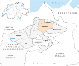
| Surrounded by | Heiden, Lutzenberg, Oberegg (AI), Thal (SG), Walzenhausen | |
| Website |
www SFSO statistics |
|
Wolfhalden is a municipality in the canton of Appenzell Ausserrhoden in Switzerland.
Around 1650 Heiden and Wolfhalden could not agree about the control over the church. This led to the creation of a church in each village in 1652, making them independent.
Wolfhalden has an area, as of 2006[update], of 7 km2 (2.7 sq mi). Of this area, 58% is used for agricultural purposes, while 30.5% is forested. Of the rest of the land, 11.4% is settled (buildings or roads) and the remainder (0.1%) is non-productive (rivers, glaciers or mountains).
Wolfhalden has a population (as of 2008[update]) of 1,719, of which about 11.3% are foreign nationals. Over the last 10 years the population has decreased at a rate of -4.3%. Most of the population (as of 2000[update]) speaks German (94.4%), with Serbo-Croatian being second most common ( 1.0%) and Italian being third ( 0.9%).
As of 2000[update], the gender distribution of the population was 51.2% male and 48.8% female. The age distribution, as of 2000[update], in Wolfhalden is; 138 people or 8.2% of the population are between 0–6 years old. 197 people or 11.7% are 6-15, and 90 people or 5.3% are 16-19. Of the adult population, 70 people or 4.1% of the population are between 20–24 years old. 483 people or 28.6% are 25-44, and 428 people or 25.3% are 45-64. The senior population distribution is 211 people or 12.5% of the population are between 65–79 years old, and 72 people or 4.3% are over 80.
In the 2007 federal election the FDP received 65.1% of the vote.
...
Wikipedia


