Walkringen
| Walkringen | ||
|---|---|---|

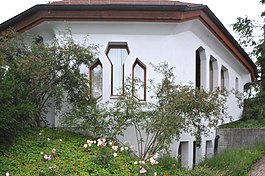
Eurythmy hall in Rüttihubelbad hamlet in Walkringen municipality
|
||
|
||
| Coordinates: 46°57′N 7°37′E / 46.950°N 7.617°ECoordinates: 46°57′N 7°37′E / 46.950°N 7.617°E | ||
| Country | Switzerland | |
| Canton | Bern | |
| District | Bern-Mittelland | |
| Area | ||
| • Total | 17.19 km2 (6.64 sq mi) | |
| Elevation | 708 m (2,323 ft) | |
| Population (Dec 2015) | ||
| • Total | 1,772 | |
| • Density | 100/km2 (270/sq mi) | |
| Postal code | 3512 | |
| SFOS number | 0626 | |
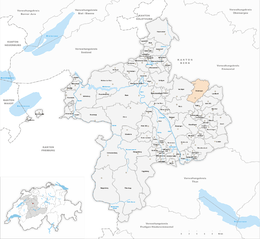
| Surrounded by | Arni, Biglen, Hasle bei Burgdorf, Landiswil, Lützelflüh, Vechigen, Worb | |
| Website |
www SFSO statistics |
|
Walkringen is a municipality in the Bern-Mittelland administrative district in the canton of Bern in Switzerland.
Walkringen is first mentioned in 1220 as Walcheringin.
The oldest trace of a settlement in the area are scattered Bronze Age artifacts were found throughout the Walkringenmoos (Walkringen Bog). Other ancient artifacts include Roman era bricks and medieval fortification. Earthen fortifications have been found on the Adlisberg, in Wikartswil, in Bigenthal and at Jegerleenscheuer, indicating that one or several local noble families ruled over the area. The three villages that today make up Walkringen have been combined and split up throughout their history. In the 13th century, the Lords of Kien ruled over Walkringen, Wikartswil and Bigenthal along with the village church. However, in 1398 Verena von Seedorf gave Walkringen village and the church to Thorberg Abbey. The Abbey established a parish in Walkringen village between 1413-18. In 1528, Bern adopted the new faith of the Protestant Reformation and secularized Thorberg Abbey and all the Abbey lands. Walkringen village was placed under the Bernese bailiff of Thorberg. The three villages remained separated until the 19th century, when they merged into a single political municipality.
The first village church in Walkringen was probably built around the 9th century, though the cemetery was first used for burials in the 7th century. A newer church was built on the foundation of the 9th century building and was first mentioned in 1239. The present church building was built in 1514-15.
Throughout their early history the villages lived by farming. The village was on the road between the Aare and Emme valleys. In 1507, the Bernese administration built a toll station in the village to collect money from this route. During the 18th and 19th centuries, Walkringen's location on the road helped turn it into a center of the canvas weaving industry. As the textile industry began to decline, saw mills and other industries moved in. Several projects drained the bogs and marshes in 1848 and further in 1944, which opened up new farm land. A railroad station on the Burgdorf-Thun line opened in 1899. The municipality has grown into regional center with the Friederika Foundation jobs training center, a conference center for the parish, the Sunnegg group home and employment center as well as a nursing home. There are school buildings in all three villages; Walkringen, Wikartswil and Bigenthal.
...
Wikipedia


