Walker Lake (Nevada)
| Walker Lake | |
|---|---|

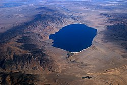
Walker Lake with Hawthorne Army Depot in the foreground
|
|
| Location |
Mineral County, Nevada, United States |
| Coordinates | 38°41′32″N 118°44′10″W / 38.69222°N 118.73611°WCoordinates: 38°41′32″N 118°44′10″W / 38.69222°N 118.73611°W |
| Primary inflows | Walker River (Does not reach Walker Lake in most years) |
| Primary outflows | evaporation |
| Catchment area | Walker River Basin |
| Basin countries | United States |
| Max. length | 11 mi (18 km) |
| Max. width | 5 mi (8.0 km) |
| Surface area | 130 km2 (50 sq mi) |
| Max. depth | 68 ft (21 m) |
Walker Lake is a natural lake, in the Great Basin in western Nevada in the United States. It is 11 mi (17 km) long and 5 mi (8 km) wide, in northwestern Mineral County along the east side of the Wassuk Range, about 75 mi (120 km) southeast of Reno. The lake is fed from the north by the Walker River and has no natural outlet except absorption and evaporation. The community of Walker Lake, Nevada, is found along the southwest shore.
The lakebed is a remnant of prehistoric Lake Lahontan that covered much of northwestern Nevada during the ice age. Although the ancient history of Walker Lake has been extensively studied by researchers seeking to establish a climatic timeline for the region as part of the Yucca Mountain Nuclear Waste Repository study, this research has raised many puzzling questions. Unlike Pyramid Lake, the lake itself has dried up several times since the end of the , probably due to natural diversions of the Walker River into the Carson Sink approximately 2,100 years ago. Also, this research found no evidence that the Walker Lake basin contained water during the Lake Lahontan highstand, although based on the surface elevation of the highstand evidenced elsewhere in the region it must have.
Walker Lake is the namesake of the geological trough in which it sits, and which extends from Oregon to Death Valley and beyond, the Walker Lane.
The area around the lake has long been inhabited by the Paiute. Beginning in the mid-19th century the introduction of agriculture upstream of Walker Lake has resulted in the water from the Walker River and its tributaries being diverted for irrigation. These diversions have resulted in a severe drop in the level of the lake. Upstream water users have exploited the Walker River for profit, resulting in the destruction of Walker Lake. According to the USGS, the level dropped approximately 181 ft (55 m) between 1882 and 2016. By June, 2016, the lake level was 3,909 feet above sea level. This is the lowest lake elevation since measurement began in 1882.
...
Wikipedia

