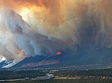
Waldo Canyon fire
| Waldo Canyon Fire | |
|---|---|

The fire moving towards the Mountain Shadows area of Colorado Springs.
|
|
| Location | San Isabel National Forest, Colorado Springs, Colorado |
| Coordinates | 38°53′24″N 104°52′19″W / 38.89°N 104.872°WCoordinates: 38°53′24″N 104°52′19″W / 38.89°N 104.872°W |
| Statistics | |
| Date(s) | June 23, 2012 – July 10, 2012 |
| Burned area | 18,247 acres (74 km2) |
| Buildings destroyed |
346 |
| Fatalities | 2 |
| Map | |
| Images | |
|---|---|
|
|
|
| Video | |
|
|
|
|
|
|
|
|
|
|
|
|
|
|
|
|
|
|
|
|
The Waldo Canyon fire was a forest fire that started approximately 4 miles (6.4 km) northwest of Colorado Springs, Colorado on June 23, 2012 and was declared 100 percent contained on July 10, 2012 after no smoke plumes were visible on a small portion of the containment line on Blodgett Peak. The fire was active in the Pike National Forest and adjoining areas, covering a total of 18,247 acres (29 sq mi; 74 km2). The fire had caused the evacuation of over 32,000 residents of Colorado Springs, Manitou Springs and Woodland Park, several small mountain communities along the southwestern side of Highway 24, and partial evacuation of the United States Air Force Academy. There were 346 homes destroyed by the fire.U.S. Highway 24, a major east-west road, was closed in both directions. The Waldo Canyon Fire resulted in insurance claims totaling more than US $453.7 million. It was the most destructive fire in Colorado state history, as measured by the number of homes destroyed, until the Black Forest Fire surpassed it almost a year later when it consumed 486 homes and damaged 28 others.
The Waldo Canyon fire started as a brush fire about noon on June 23, 2012 in a valley of Rampart Range in the Pike National Forest, about 3 miles (4.8 km) west of Colorado Springs and north of U.S. Highway 24. The fire, first spotted and caught on video by cyclists on the range, spread quickly and reached one of the ridges. Air support was requested at 12:24 p.m. by the Colorado Springs Fire Department. Helicopters began dropping water on the fire two days after the fire began. Erratic winds caused the fire to spread rapidly in the northwest and south directions. By 3 p.m., the fire grew to 600 acres spreading towards the towns of Chipita Park, Green Mountain Falls, and Cascade, Colorado. It also spread towards the western and northwestern areas of the Colorado Springs area and Manitou Springs. Residents began to evacuate as the fire intensified. Planes dropped retardant slurry on what they believed was the Pyramid Mountain Fire, which was a less than 20 acre fire in the same area the night before. As the fire intensified, flames seemed to reach 150 feet above the treetops.
...
Wikipedia

