Wakuya, Miyagi
|
Wakuya 涌谷町 |
|||
|---|---|---|---|
| Town | |||

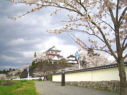
Wakuya Castle
|
|||
|
|||
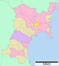
 Location of Wakuya in Miyagi Prefecture |
|||
| Coordinates: 38°32′23″N 141°07′41.4″E / 38.53972°N 141.128167°ECoordinates: 38°32′23″N 141°07′41.4″E / 38.53972°N 141.128167°E | |||
| Country | Japan | ||
| Region | Tōhoku | ||
| Prefecture | Miyagi | ||
| District | Tōda | ||
| Area | |||
| • Total | 82.16 km2 (31.72 sq mi) | ||
| Population (February 29, 2016) | |||
| • Total | 16,940 | ||
| • Density | 203/km2 (530/sq mi) | ||
| Time zone | Japan Standard Time (UTC+9) | ||
| - Tree | Cryptomeria | ||
| - Flower | Sakura | ||
| Phone number | 0229-43-2111 | ||
| Address | 153-2 Shin-machi ura, Wakuya-chō, Tōda-gun, Miyagi-ken 987-0192 | ||
| Website | Official website | ||
Wakuya (涌谷町 Wakuya-chō?) is a town located in Tōda District, Miyagi Prefecture, in the Tohoku region of northern Japan. As of September 2015, the town had an estimated population of 16,684 and a population density of 203 persons per km². The total area was 82.16 square kilometres (31.72 sq mi). The area is noted for its rice production.
Wakuya is in north-central Miyagi Prefecture.
The area of present-day Wakuya was part of ancient Mutsu Province, and has been settled since at least the Jomon period by the Emishi people. During the Nara period, gold was discovered in the area. During later portion of the Heian period, the area was ruled by the Northern Fujiwara. During the Sengoku period, the area was contested by various samurai clans before the area came under the control of the Date clan of Sendai Domain during the Edo period, under the Tokugawa shogunate.
The modern town of Wakuya was established on June 1, 1889 with the establishment of the municipalities system. The town annexed the neighboring village of Moto-Wakuya on December 1, 1948, and the village of Nonodake on July 15, 1955. The 2011 Tōhoku earthquake and tsunami destroyed numerous buildings in the town, and resulted in one fatality.
...
Wikipedia


