Wakeman, Ohio
| Wakeman, Ohio | |
|---|---|
| Village | |

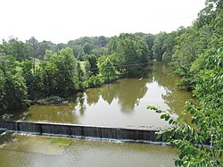
Dam on the Vermilion River
|
|
 Location of Wakeman, Ohio |
|
 Location of Wakeman in Huron County |
|
| Coordinates: 41°15′17″N 82°24′14″W / 41.25472°N 82.40389°WCoordinates: 41°15′17″N 82°24′14″W / 41.25472°N 82.40389°W | |
| Country | United States |
| State | Ohio |
| County | Huron |
| Area | |
| • Total | 0.85 sq mi (2.20 km2) |
| • Land | 0.83 sq mi (2.15 km2) |
| • Water | 0.02 sq mi (0.05 km2) |
| Population (2010) | |
| • Total | 1,047 |
| • Estimate (2012) | 1,044 |
| • Density | 1,261.4/sq mi (487.0/km2) |
| Time zone | Eastern (EST) (UTC-5) |
| • Summer (DST) | EDT (UTC-4) |
| ZIP code | 44889 |
| Area code(s) | 440 |
Wakeman is a village in Huron County, Ohio, United States, along the Vermilion River. Its namesake was Jesup Wakeman, an early settler of Fairfield County, Connecticut, who was involved in western land speculation between 1800 and 1840. The population was 1,047 at the 2010 census.
Wakeman is served by a branch of the Willard Memorial Library.
Wakeman is located at 41°15′17″N 82°24′14″W / 41.25472°N 82.40389°W (41.254702, -82.403938).
According to the United States Census Bureau, the village has a total area of 0.85 square miles (2.20 km2), of which 0.83 square miles (2.15 km2) is land and 0.02 square miles (0.05 km2) is water.
As of the census of 2010, there were 1,047 people, 402 households, and 288 families residing in the village. The population density was 1,261.4 inhabitants per square mile (487.0/km2). There were 441 housing units at an average density of 531.3 per square mile (205.1/km2). The racial makeup of the village was 99.0% White, 0.2% African American, 0.1% Native American, 0.1% from other races, and 0.6% from two or more races. Hispanic or Latino of any race were 1.2% of the population.
...
Wikipedia
