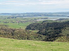
Waitetuna River
| Waitetuna River | |
|---|---|

the Waitetuna River reaches the Waitetuna arm of Whaingaroa Harbour through the trees (centre left). Beyond are Haroto Bay and Paritata Peninsula
|
|
| Country | New Zealand |
| Basin features | |
| Main source | 200 m (660 ft) |
| River mouth |
Raglan Harbour 0 m (0 ft) |
| Basin size | 167 km2 (64 sq mi) |
| Physical characteristics | |
| Length | 17 km (11 mi) |
The Waitetuna River is a river of the Waikato Region of New Zealand's North Island. It flows generally northwest from its sources southwest of Whatawhata to reach the southeastern coast of the Raglan Harbour.
Mainly Upper Pliocene–Lower Okete volcanics erupted from many vents, mainly forming greywacke, with small areas of tephra.
A study for Regional Council said, "Harbour-wide sediment accumulation rates (SAR) have averaged 0.3-0.5 mm yr−1 over the last 8000-6500 years. The effects of large-scale catchment deforestation (1890-1920s), conversion to pasture and plantation forestry (1985-) on sedimentation have occurred very differently in the Waingaro and Waitetuna arms of the harbour. In the Waitetuna arm, 14C dating of shell and exotic-pollen profiles preserved in core 12B indicate that pre-human SAR of 0.35 mm yr−1 has increased threefold following deforestation and averaging 1.1 mm yr−1 since 1890. Pine pollen, which is produced in large quantities and widely dispersed by the wind, suggests that SAR have further increased to 2.5 mm yr−1 since the early 1990s. At Okete Bay (core 10B) pre-human SAR averaged 0.5 mm yr−1. The pine pollen profile indicates that SAR have averaged 8 mm yr−1 since the early 1990s."
A larger than average part of that post-1890 change took place when the 3,000 acre Puketutu block, near the estuary, was bought by the Watkins Brothers in 1901. They ran a sawmill in Raglan from 1905 to 1911, largely supplied with timber floated down the river and then towed across the harbour.
That change took place following sale of most land in the area to settlers and the river was a boundary of the first major land sale. "On 22 March 1851, eighteen chiefs of Ngati-Mahanga and Ngati-Hourua, headed by William Naylor, sold to Queen Victoria for the sum of £400, 19,680 acres of country bordering on the southern shores of the harbour. The western boundary of the Whaingaroa Block, as it came to be known, began at Putoetoe (the point on which the town of Raglan now stands) and followed the Opotoru Stream inland. Leaving that stream at its junction with the Hutewai, the line ran south beyond Te Mata to a point "marked by a hole dug by the side of the path to Aotea." Here it turned north-eastward to run (again in a straight line) for eight miles through dense forest to meet the Waitetuna River, the last few miles of which formed the eastern boundary. The 30 square miles thus enclosed included most of the present rich farmlands lying between Karioi Mountain on the west and the Waitetuna on the east; the harbour in the north and the Wharauroa Plateau in the south. Reporting to the Colonial Secretary on 15 April 1852, after paying over the second instalment for the land, Ligar drew attention to the fact that the block was surrounded on three sides by water, thus solving to some extent the problem of communication. "The soil," he said, "is of the finest description, having for its basis a limestone formation. It is also well watered and has an abundant supply of timber for fuel, for building purposes or for commerce."
...
Wikipedia
