Waimakariri District
| Waimakariri District | ||
|---|---|---|
| Territorial authority | ||

Council offices in Rangiora
|
||
|
||
 |
||
| Country |
|
|
| Island | South Island (Te Waipounamu) | |
| Region | Canterbury | |
| Named for | Waimakariri River | |
| Seat | Rangiora | |
| Towns |
List
|
|
| Government | ||
| • Mayor | David Ayers | |
| Area | ||
| • Total | 2,219 km2 (857 sq mi) | |
| Population (June 2016) | ||
| • Total | 57,800 | |
| • Density | 26/km2 (67/sq mi) | |
| Demonym(s) | Waimakaririan | |
| Time zone | NZST (UTC+12) | |
| • Summer (DST) | NZDT (UTC+13) | |
| Area Code | 03 | |
| Website | www |
|
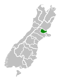
The Waimakariri District is a local government district, located in the Canterbury region of New Zealand's South Island. It is named after the Waimakariri River, which forms the district's southern boundary, separating it from Christchurch City and the Selwyn District. It is bounded in the north by the Hurunui District and in the east by the Pacific Ocean.
The district was established on 1 April 1989 following the merger of Rangiora District and Eyre County. The district covers 2,219 square kilometres (857 sq mi), and is home to 57,800 people.Rangiora is the district seat and largest town, with other major towns including Kaiapoi, Oxford, Pegasus and Woodend.
The current district mayor is David Ayers, who defeated incumbent mayor Ron Keating in the 2010 local body elections.
The Waimakariri District lies to the north of the Waimakariri River in North Canterbury. The major urban areas are Rangiora and Kaiapoi, which are respectively about 20 and 30 minutes travelling time by car from the centre of Christchurch City.
There are other urban settlements including Woodend and Oxford, as well as a number of village and beach settlements.
The District occupies some 225,000 hectares, and extends from Pegasus Bay in the east to the Puketeraki Range in the west. It is bounded to the north by the Hurunui District.
In pre-European times there were several important Ngai Tahu settlements in the area now occupied by the Waimakariri District. The centre of Ngai Tahu was the pa of Taurakautahi, known as Kaiapoi. Today, the hapu Ngai Tuahuriri is based at Tuahiwi, to the north of Kaiapoi. People who identify themselves as having NZ Maori ancestry presently represent 8.5% of the District’s population, and most of these people live in the eastern part of the District.
During the early years of European settlement, Kaiapoi developed as a river port. Rangiora was the area’s main market town, and the development of Oxford was based on timber milling. The roles of the District’s main urban areas have changed during recent years, mainly as the result of the rapid population growth.
European settlement concentrated on the fertile soils of the plains. Until the middle of the 20th century extensive agricultural and pastoral farming predominated. More recently, horticultural and forestry have gained in importance. Today some 11% of the District’s labour force is now involved with agriculture, forestry and fishing.
...
Wikipedia

