Wailea-Makena, Hawaii
| Wailea-Makena, Hawaii | |
|---|---|
| Former CDP | |

View from Upcountry Maui
|
|
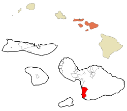
 Location in Maui County and the state of Hawaii |
|
| Coordinates: 20°41′24″N 156°26′21″W / 20.69000°N 156.43917°WCoordinates: 20°41′24″N 156°26′21″W / 20.69000°N 156.43917°W | |
| Country | United States |
| State | Hawaii |
| County | Maui |
| Area | |
| • Total | 26.8 sq mi (69.5 km2) |
| • Land | 22.6 sq mi (58.6 km2) |
| • Water | 4.2 sq mi (10.8 km2) |
| Population (2000) | |
| • Total | 5,671 |
| • Density | 250.6/sq mi (96.7/km2) |
| Time zone | Hawaii-Aleutian (UTC-10) |
| Area code(s) | 808 |
| FIPS code | 15-76935 |
Wailea-Makena was a census-designated place (CDP) in Maui County, Hawaiʻi, United States, during the 2000 census, at which time its population was 5,671. The area was split into two CDPs, Wailea and Makena, for the 2010 census.
Wailea-Makena was located at 20°41′24″N 156°26′21″W / 20.69000°N 156.43917°W (20.690104, -156.439108).
According to the United States Census Bureau, the CDP had a total area of 26.8 square miles (69 km2), of which, 22.6 square miles (59 km2) of it is land and 4.2 square miles (11 km2) of it (15.62%) is water.
As of the census of 2000, there were 5,671 people, 2,520 households, and 1,522 families residing in the CDP. The population density is 250.6 people per square mile (96.8/km²). There were 5,099 housing units at an average density of 225.3 per square mile (87.0/km²). The racial makeup of the CDP was 75.70% White, 0.79% African American, 0.51% Native American, 10.53% Asian, 2.10% Pacific Islander, 1.02% from other races, and 9.35% from two or more races. Hispanic or Latino of any race were 5.01% of the population.
...
Wikipedia
