Waikerie
|
Waikerie South Australia |
|
|---|---|

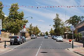
Peake Tce, the main street of Waikerie
|
|
| Coordinates | 34°10′0″S 139°59′0″E / 34.16667°S 139.98333°ECoordinates: 34°10′0″S 139°59′0″E / 34.16667°S 139.98333°E |
| Population | 1,744 (2006 census) |
| Postcode(s) | 5330 |
| Location | |
| LGA(s) | District Council of Loxton Waikerie |
| State electorate(s) | Chaffey |
| Federal Division(s) | Barker |
Waikerie is a rural town in the Riverland region of South Australia on the south bank of the Murray River. At the 2006 census, Waikerie had a population of 1,744. The Sturt Highway passes to the south of the town at the top of the cliffs. There is a cable ferry crossing the river to provide vehicle access from the north side of the river.
The town of Waikerie derives its name from Weikari, which is claimed to mean 'the rising'. However some linguistic anthropologists argue that the name refers to the spider creator god from local creation myths. The Waikerieness was said to fend off monthly centipede infestations by leaking seeds all over the area. This refers to the emergence of many ghost moths (especially Trictena argentata : Hepialidae) from the ground among the river red gums after heavy rain.
Waikerie is well known for citrus growing and gliding, as the flat dry terrain provides good thermals. Waikerie hosted the 14th World Gliding Championships in 1974.
The historic former Irrigation Pumping Station Chimney in Scenic Lookout Reserve is listed on the South Australian Heritage Register.
Waikerie is in the District Council of Loxton Waikerie, the South Australian House of Assembly electoral district of Chaffey and the Australian House of Representatives Division of Barker.
Waikerie Airport is near Waikerie. It is home to the Waikerie Gliding Club. It has two runways 08/26 and 02/20.
...
Wikipedia

