Electoral district of Chaffey
|
Chaffey South Australia—House of Assembly |
|
|---|---|

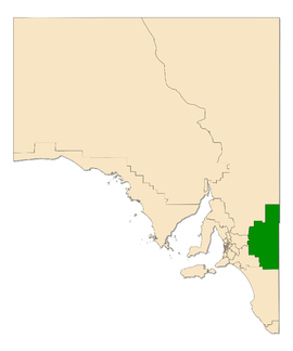
Electoral district of Chaffey (green) in South Australia
|
|
| State | South Australia |
| Created | 1938 |
| MP | Tim Whetstone |
| Party | Liberal Party of Australia (SA) |
| Namesake | George Chaffey and William Chaffey |
| Electors | 24,576 (2014) |
| Area | 25,477 km2 (9,836.7 sq mi) |
| Demographic | Rural |
| Coordinates | 34°32′16″S 140°16′14″E / 34.53778°S 140.27056°ECoordinates: 34°32′16″S 140°16′14″E / 34.53778°S 140.27056°E |
Chaffey, created in 1936, is an electorate for the South Australian House of Assembly. It covers the Riverland region of South Australia including the towns of Renmark, Berri, Barmera, Loxton and Waikerie. The seat is named after brothers George and William Chaffey who established the irrigation area along the Murray River from 1886.
Usually a comfortably conservative seat, Chaffey was won three times by Labor's Reg Curren as their most marginal seat – in 1962 on 50.1%, 1965 on 50.7% and 1970 on 50.2%, two-party-preferred. Chaffey was one of the seats that put Labor in government in 1965 after three decades in opposition due to the Playmander, and one of two seats that put the Liberal and Country League back in government in 1968. The LCL won it back in 1973, and Labor has never retaken it. The 1975 election saw permanent large two-party swings away from Labor in a few rural seats − 13.5 percent in Chaffey, 15.5 percent in Mount Gambier and 16.4 percent in Millicent.
...
Wikipedia
