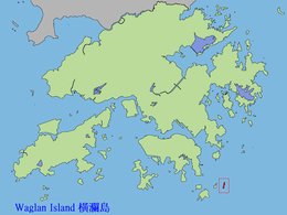
Waglan Island
| 橫瀾島 | |
|---|---|
| Location of Waglan Island within Hong Kong | |
| Geography | |
| Administration | |
| Waglan Island | |||||||||
| Traditional Chinese | 橫瀾島 | ||||||||
|---|---|---|---|---|---|---|---|---|---|
|
|||||||||
| Transcriptions | |
|---|---|
| Yue: Cantonese | |
| Yale Romanization | Wàahng làahn dóu |
| Jyutping | Waang4 laan4 dou2 |

Aerial view of Waglan Island
|
|
|
Hong Kong
|
|
| Location | Waglan Island, Hong Kong |
|---|---|
| Coordinates | 22°10′55″N 114°18′10″E / 22.181991°N 114.302880°E |
| Year first constructed | 1893 |
| Construction | cast iron tower |
| Tower shape | cylindrical tower with balcony and lantern |
| Markings / pattern | white tower with a horizontal red band under the balcony, white lantern |
| Height | 16 metres (52 ft) |
| Focal height | 69 metres (226 ft) |
| Range | 24 nautical miles (44 km; 28 mi) |
| Characteristic | Fl (2) W 20s. |
| Fog signal | two blasts every 60s. |
| Admiralty number | P3578 |
| NGA number | 19326 |
| ARLHS number | HOK-005 |
| Hong Kong number | HK-102 |
Waglan Island (Chinese: 橫瀾島) is a member of the Po Toi group of islands in Hong Kong. It hosts a ground of meteorological observation and recording.
The Waglan Lighthouse on Waglan Island has been listed as a declared monument of Hong Kong. It commenced operation in 1893; it is one of the five surviving pre-war lighthouses in Hong Kong.
Coordinates: 22°10′55″N 114°18′12″E / 22.18194°N 114.30333°E
...
Wikipedia


