Vitória, Brasil
| Vitória | |||
|---|---|---|---|
| Municipality | |||
|
Município de Vitória Municipality of Vitória |
|||

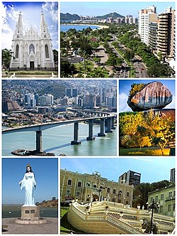
From the top, left to right: Canto's Beach, Boi's Island, Third Bridge, Anchieta Palace, Suá's Beach, and Valentine's Plaza (at night)
|
|||
|
|||
| Nickname(s): Honey Island Sun City Vix |
|||
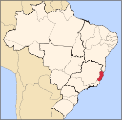
 Location in the Espírito Santo |
|||
 |
|||
| Coordinates: 20°17′20″S 40°18′30″W / 20.28889°S 40.30833°WCoordinates: 20°17′20″S 40°18′30″W / 20.28889°S 40.30833°W | |||
| Country |
|
||
| Region | Southeast | ||
| State |
|
||
| Founded | September 8, 1551 | ||
| Government | |||
| • Mayor | Luciano Rezende (PPS) | ||
| Area | |||
| • Municipality | 93.381 km2 (36.055 sq mi) | ||
| • Metro | 3,204.26 km2 (1,237.17 sq mi) | ||
| Elevation | 4 m (13 ft) | ||
| Population (2015 estimate) | |||
| • Municipality | 355.875 | ||
| • Density | 3,546.7/km2 (9,186/sq mi) | ||
| • Metro | 1,857,616 | ||
| Time zone | UTC-3 (UTC-3) | ||
| Postal Code | 29000-000 | ||
| Area code(s) | (+55) 27 | ||
| Demonym | vitoriense | ||
| Website | Vitória, Espírito Santo | ||
| Vitória | ||||||||||||||||||||||||||||||||||||||||||||||||||||||||||||
|---|---|---|---|---|---|---|---|---|---|---|---|---|---|---|---|---|---|---|---|---|---|---|---|---|---|---|---|---|---|---|---|---|---|---|---|---|---|---|---|---|---|---|---|---|---|---|---|---|---|---|---|---|---|---|---|---|---|---|---|---|
| Climate chart () | ||||||||||||||||||||||||||||||||||||||||||||||||||||||||||||
|
||||||||||||||||||||||||||||||||||||||||||||||||||||||||||||
|
||||||||||||||||||||||||||||||||||||||||||||||||||||||||||||
| J | F | M | A | M | J | J | A | S | O | N | D |
|
77
32
24
|
54
32
24
|
87
32
24
|
72
30
23
|
46
29
21
|
43
28
19
|
46
27
19
|
45
27
19
|
51
27
20
|
76
28
22
|
143
29
23
|
175
30
24
|
| Average max. and min. temperatures in °C | |||||||||||
| Precipitation totals in mm | |||||||||||
| Source: MSN Weather | |||||||||||
| Imperial conversion | |||||||||||
|---|---|---|---|---|---|---|---|---|---|---|---|
| J | F | M | A | M | J | J | A | S | O | N | D |
|
3
90
75
|
2.1
90
75
|
3.4
90
75
|
2.8
86
73
|
1.8
84
70
|
1.7
82
66
|
1.8
81
66
|
1.8
81
66
|
Wikipedia
...
| |||


