Virginia State Route 27
| State Route 27 | ||||
|---|---|---|---|---|
 |
||||
| Route information | ||||
| Maintained by VDOT | ||||
| Length: | 2.54 mi (4.09 km) | |||
| Existed: | 1964 – present | |||
| Major junctions | ||||
| West end: |
|
|||
| East end: | George Washington Parkway in Washington, DC | |||
| Highway system | ||||
|
||||
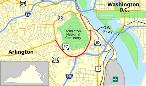
State Route 27 (SR 27) is a freeway in Arlington County, Virginia, in the United States. It was built during World War II to connect the Pentagon with U.S. Route 50 (US 50) and northern Arlington to the west and Washington, DC, to the east. Its 2.54-mile (4.09 km) route parallels the southern boundaries of Arlington National Cemetery. At its southernmost point, Route 27 passes through a complex interchange with Interstate 395 (I-395, Shirley Highway). called the "Mixing Bowl," although local motorists more recently use that term also to refer to the Springfield Interchange on the Capital Beltway in Springfield. It is an important commuter route as well as providing access to a number of military installations, the cemetery and national memorials. Because Route 27 is the closest road to the site of the September 11 attack on the Pentagon, the route has been designated the "9/11 Heroes Memorial Highway."
Route 27 begins at an interchange with US 50. It then has an interchange with 2nd Street South, which serves as an entrance to Fort Myer. The next interchange with Route 244 offers a very short merge area because of the proximity to the exit ramps to I-395 and Arlington Ridge Road. The Mixing Bowl is the first interchange in Northern Virginia with a three level bridge—ramp from I-395 to westbound Route 27 on the lowest level, eastbound Route 27 to Mixing Bowl in the middle; and southbound I-395 on top. In 1970 this was followed by a second three level stack—Joyce Street South on the lowest level, eastbound Route 27 on the middle bridge and I-395 on the top level.
...
Wikipedia

