Vindafjord
| Vindafjord kommune | |||
|---|---|---|---|
| Municipality | |||

View of the municipal centre of Ølensjøen
|
|||
|
|||
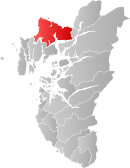
 Vindafjord within Rogaland |
|||
| Coordinates: 59°32′44″N 05°49′05″E / 59.54556°N 5.81806°ECoordinates: 59°32′44″N 05°49′05″E / 59.54556°N 5.81806°E | |||
| Country | Norway | ||
| County | Rogaland | ||
| District | Haugaland | ||
| Administrative centre | Ølensjøen | ||
| Government | |||
| • Mayor (2011) | Ole Johan Vierdal (Sp) | ||
| Area | |||
| • Total | 620.59 km2 (239.61 sq mi) | ||
| • Land | 598.89 km2 (231.23 sq mi) | ||
| • Water | 21.70 km2 (8.38 sq mi) | ||
| Area rank | 179 in Norway | ||
| Population (2015) | |||
| • Total | 8,765 | ||
| • Rank | 128 in Norway | ||
| • Density | 14.6/km2 (38/sq mi) | ||
| • Change (10 years) | +86.5% % | ||
| Demonym(s) | Vindafjording | ||
| Time zone | CET (UTC+1) | ||
| • Summer (DST) | CEST (UTC+2) | ||
| ISO 3166 code | NO-1160 | ||
| Official language form | Nynorsk | ||
| Website | www |
||
|
|
|||
Vindafjord is a municipality in Rogaland county, Norway. It is part of the traditional district of Haugaland. Since 2005, the administrative centre of the municipality has been the village of Ølensjøen, prior to that time it was the village of Sandeid. Other villages in the municipality include Bjoa, Imslandsjøen, Ølensvåg, Skjold, Vats, Vikebygd, and Vikedal. The municipality is centered on the Vindafjorden and Sandeidfjorden in the east and it lies north and east of the Skjoldafjorden in the west.
Vindafjord was established as a new municipality on 1 January 1965 after a major municipal merger that resulted from the work of the Schei Committee. The municipality of Sandeid and parts of the municipalities of Vats, Imsland, Skjold, and Vikedal. Initially, Vindafjord had 4,616 residents. On 1 January 1969, the Sponevik farm (population: 6) was transferred from Vindafjord to the neighboring municipality of Tysvær. Then on 1 January 1978, the Vormestrand area along the southern shore of the Vindafjorden (population: 13) was transferred to neighboring Suldal municipality.
...
Wikipedia


