Villeray, Montreal
| Villeray | |
|---|---|
| Neighbourhood | |

Bicycle path on Boyer Street in Villeray.
|
|
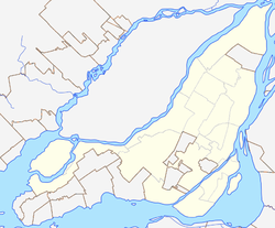
| Location of Villeray in Montreal | |
| Coordinates: 45°32′25″N 73°37′40″W / 45.540143°N 73.627882°WCoordinates: 45°32′25″N 73°37′40″W / 45.540143°N 73.627882°W | |
| Country | Canada |
| Province | Quebec |
| City | Montreal |
| Borough | Villeray-Saint-Michel-Parc-Extension |
Villeray is a neighbourhood in Montreal, Quebec, Canada. It is part of the Villeray–Saint-Michel–Parc-Extension borough and is situated in the north-central part of the Island of Montreal.
The village of Villeray took its name from Louis Rouer de Villeray (1628-1700), who held various positions in the French regime. It became a town in 1896, before which the area had been farmland. When it was annexed to Montreal in 1905, its population was 800. At the time, Villeray was surrounded by quarries that provided material for the construction of many of the buildings in the area, as well as for several of the city's major landmarks. For some years, its inhabitants were chiefly stone workers, farmers and owners of small businesses.
The territory of Villeray was well provided with streams and ponds and very amenable to cultivation. The original Jarry Farm covered 64 arpents (approximately 22 hectares, or 54 acres) and stretched as far north as the present-day Metropolitan (highway 40), south to Villeray St., east to St-Hubert and west to Foucher. The owner, one Stanislas Jarry, broke the land up into 680 lots at the beginning of the 20th century. Other members of his family owned land in what would eventually be called Villeray–Saint-Michel–Parc-Extension.
Presently the district of Villeray is enclosed between Avenue Casgrain in the west, Boulevard Jean-Talon in the south, Rue Garnier in the east and the Metropolitan (highway 40) to the north. These borders were determined in the creation of the borough of Villeray–Saint-Michel–Parc-Extension, which was created on January 1, 2002, following the municipal reorganization of Montreal.
Originally Villeray's houses were wooden ones, typically owned by workers, with sheds and stables in back. From 1915 to 1930, Villeray saw a boom which brought with it the need for schools, churches, a public bath and a fire station, built at the corner of Jarry and St-Hubert in 1912.
The imposing Montreal Institute for the Deaf, with a façade made of Montreal stone, was built near Faillon and de Castelnau during World War I by the Clercs de Saint-Viateur.
...
Wikipedia

