Vilaine
| Vilaine | |
|---|---|

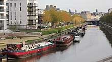
The Vilaine in Rennes.
|
|
| Native name | La Vilaine |
| Country | France |
| Basin features | |
| Main source |
Juvigné, Mayenne 175 m (574 ft) 48°13′46″N 01°03′11″W / 48.22944°N 1.05306°W |
| River mouth |
Atlantic Ocean 47°30′20″N 2°29′57″W / 47.50556°N 2.49917°WCoordinates: 47°30′20″N 2°29′57″W / 47.50556°N 2.49917°W |
| Basin size | 10,882 km2 (4,202 sq mi) |
| Physical characteristics | |
| Length | 218.1 km (135.5 mi) |
| Discharge |
|
The Vilaine (Breton: Gwilen) is a river in Brittany, in the west of France. The river's source is in the Mayenne département (53), and flows out in the Atlantic Ocean at Pénestin in the Morbihan département (56). It is 218 km long. The river is joined to the Ille and the Rance by means of the Canal d'Ille-et-Rance by the commune of Rennes.
The river passes through 4 départements (Mayenne, Ille-et-Vilaine, Loire-Atlantique and Morbihan) and 4 main towns (Rennes, Vitré, Redon and La Roche-Bernard).
Three barrages were built around Vitré, Ille-et-Vilaine to avoid floods, the drinkable water and leisure spaces:
The river has a flow ranging between 2 and 1500 m3/s
The Vilaine is part of Brittany's canal system. The section from Rennes to the Atlantic Ocean is navigable for smaller craft. In Rennes the river connects to the Canal d'Ille et Rance, in Redon it crosses the Canal de Nantes à Brest. (Source: NoorderSoft Waterways Database)
...
Wikipedia
