Vila Velha
| Vila Velha | |||
|---|---|---|---|
| Municipality | |||
| The Municipality of Vila Velha | |||

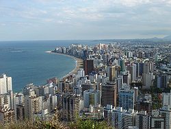
Skyline of Vila Velha.
|
|||
|
|||
| Nickname(s): The Land of the Green Shins (Portuguese: Terra dos Canelas-Verdes) | |||
 Location in the State of Espírito Santo |
|||
| Country |
|
||
| Region | Southeast | ||
| State |
|
||
| Founded | May 23, 1535 | ||
| Government | |||
| • Mayor | Rodney Miranda(DEM) | ||
| Area | |||
| • Total | 208 km2 (80 sq mi) | ||
| Population (2010) | |||
| • Total | 427,579 | ||
| • Density | 1,906/km2 (4,940/sq mi) | ||
| Time zone | UTC-3 (UTC-3) | ||
| Postal Code | 29100-000 | ||
| Area code(s) | +55 27 | ||
| Website | Vila Velha, Espírito Santo | ||
Coordinates: 20°20′11″S 40°17′37″W / 20.33639°S 40.29361°W
Vila Velha ([ˈvilɐ ˈvɛʎɐ]; Portuguese for "Old town") is a coastal town in Espírito Santo, Brazil. It lies across from Vitória, the state capital. Its population was 396,323 (2005) and its area is 208.82 km².
Vila Velha forms part of the Greater Vitória metropolitan area. To the north is Vitória, to the west Cariacica and Viana, to the south Guarapari, and to the east the Atlantic Ocean. The Deputy Darcy Castelo de Mendonça Bridge, known as Third Bridge (Portuguese: Terceira Ponte), is the second tallest bridge in Brazil, connecting and reducing the distance between the cities of Vila Velha and Vitória.
The Jacarenema Ecological Reserve, a 307 hectares (760 acres) conservation area established in 1997, lies along the coast to the south of the main city and contains the mangrove estuary of the Jucu River. The Morro do Penedo Natural Monument protects a granite rock mass about 132 metres (433 ft) high on the coast of Vitória Bay.
...
Wikipedia


