
Viernheim
| Viernheim | ||
|---|---|---|
|
||

Viernheim
|
||
|
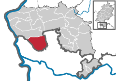
Location of Viernheim within Bergstraße district
  |
||
| Coordinates: 49°32′30″N 8°34′43″E / 49.54167°N 8.57861°ECoordinates: 49°32′30″N 8°34′43″E / 49.54167°N 8.57861°E | ||
| Country | Germany | |
| State | Hesse | |
| Admin. region | Darmstadt | |
| District | Bergstraße | |
| Government | ||
| • Mayor | Matthias Baaß (SPD) | |
| Area | ||
| • Total | 48.41 km2 (18.69 sq mi) | |
| Elevation | 98 m (322 ft) | |
| Population (2015-12-31) | ||
| • Total | 34,146 | |
| • Density | 710/km2 (1,800/sq mi) | |
| Time zone | CET/CEST (UTC+1/+2) | |
| Postal codes | 68519 | |
| Dialling codes | 06204 | |
| Vehicle registration | HP | |
| Website | www.viernheim.de | |

Viernheim is a midsize industrial town on Mannheim’s outskirts and is found in the Rhine Neckar agglomeration and economic area. It is the second biggest town in Bergstraße district in Hesse, Germany. Since 1994 it has also borne the title Brundtlandstadt, as it has been taking part in an energy conservation pilot project. In 1968, the town hosted the eighth Hessentag state festival.
Viernheim lies in the Rhine rift, and although it also lies in Hesse, it is bounded on the west, south and east by Baden-Württemberg. North of the Viernheim woods, in Lampertheim, begins the Hessisches Ried. East of Viernheim lies the town of Weinheim, which is where the district’s namesake Bergstraße begins, and which also marks the beginning of the Odenwald. The town lies roughly 10 kilometres (6 miles) northeast of Mannheim, 10 km (6 mi) east of the Rhine and 10 km (6 mi) west of the Bergstrasse.
Viernheim borders in the north on the town of Lampertheim (in Hessen), in the northeast on the towns of Hemsbach and Weinheim, in the south on the community of Heddesheim (all three in the Rhein-Neckar-Kreis), and in the west on the district-free city of Mannheim (all in Baden-Württemberg).
Viernheim is divided into several sections. It has been the local, everyday speech and town expansions, though, that have yielded most of the divisions. They therefore have no precisely defined bounds. The Stadtkern, or town core, is made up of the Innenstadt (“Inner Town”) and the Altstadt (“Old Town) lying around it. Among the other neighbourhoods are the Nordstadt (“North Town”, north of Nibelungenstraße and Wormser Straße), the Nordweststadt (“Northwest Town”, west of Kreuzstraße and Am Königsacker), the Tivoli (in the south at the Rhein-Neckar-Zentrum), Hinter den Zäunen (“Behind the Fences”, south of the OEG tracks), Gewerbegebiet Eins (“Commercial Area One”, in the northeast, north of Friedrich-Ebert-Straße and east of Lorscher Straße) and the new development that has sprung up over the last few years, Bannholzgraben, east of Janusz-Korczak-Allee (L 3111). Moreover, there are also the Sportgebiet West (“Sport Area West”, west of the A 6), the two outlying centres which are each made up of only one road, Neuzenlache and Ziegelhütte (south of the A 659 and the outlying farms northeast of town.
...
Wikipedia