Victory Square (Vancouver)
| Victory Square | |
|---|---|

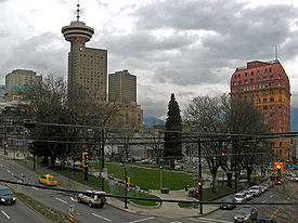
Victory Square park, Vancouver
|
|
| Type | Public Park |
| Location | Vancouver, British Columbia |
| Coordinates | 49°16′55.56″N 123°06′36.72″W / 49.2821000°N 123.1102000°WCoordinates: 49°16′55.56″N 123°06′36.72″W / 49.2821000°N 123.1102000°W |
| Area | 0.9 acres (0.36 ha) |
| Created | 1886 |
| Operated by | City of Vancouver |
Victory Square is a park in Vancouver, British Columbia, Canada. The square is bordered by West Hastings Street to the northeast, West Pender Street to the southwest, Cambie Street to the southeast, and Hamilton Street to the northwest. The term is also used to refer to the neighbourhood immediately surrounding the square.
Victory Square was at one time the grounds of the city's provincial courthouse, which was torn down in 1911–13 when the new Francis Rattenbury-designed courthouse on Georgia Street was opened (now the Vancouver Art Gallery). The location had significance when it was chosen, as it stands at the intersection of the old Granville townsite (aka Gastown) and the CPR Townsite, which was the downtown-designated land grant obtained by the CPR as part of the deal to locate the terminus and thereby found the city (the corner of Hastings and Hamilton is the northern tip of the CPR Townsite). An area of 0.9 acres (3,600 m2) out of the 480 acres (1.9 km2) allotted to the CPR was held aside as "Government Square" on February 13, 1886. The southwest corner of Hamilton and Hastings Streets is where L. A. Hamilton drove the first survey stake to commence laying out the street system for the city.
Boyd & Clendenning were contracted by the CPR to begin felling the forest at a rate of $26 per acre and an extra $2 per acre for lopping off large branches. A tangled mass soon built up to 20 feet (6.1 m) thick that was to be the kindling for the great fire that leveled the townsite.
It was down the park's hillside that the clearing crews of the CPR entered Gastown a few steps ahead of the firestorm that destroyed the city on June 13, 1886, heading for their quarters in the Regina Hotel at Cambie and Water where they had themselves stored water and wetted blankets as safety precaution (it was the only building in that part of the city to survive the fire). Until that year, however, the site of Victory Square as with all of the downtown peninsula outside of Gastown had been dense west coast rainforest, with trees standing in dark, thick groves hundreds of feet high and also a small creek (now vanished).
On the northern side of the square, on a plaza flanking Hastings Street, lies the Vancouver war memorial, the Victory Square Cenotaph. The cenotaph is approximately 30 feet (9.1 m) tall, and is a triangular edifice whose shape conforms to that of the square. The pillar is of Nelson Island granite engraved with suitable inscriptions, and is kept continuously banked high with wreaths of flowers and adorned with national flags.
...
Wikipedia
