Victoria Lines
| Victoria Lines | |
|---|---|
| Northern Malta (Rabat, Mġarr, Mosta, Naxxar and Għargħur) |
|

|
|
 |
|
| Coordinates | 35°54′12.7″N 14°22′43.5″E / 35.903528°N 14.378750°E |
| Type | Defensive line |
| Site information | |
| Condition | Partially intact |
| Website | www.victorialinesmalta.com |
| Site history | |
| Built | 1875–1899 |
| Built by | British Empire |
| In use | 1880s–1907 |
| Materials | Limestone |
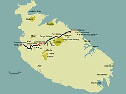
The Victoria Lines, originally known as the North West Front and sometimes unofficially known as the Great Wall of Malta, are a line of fortifications flanked by defensive towers, that spans 12 kilometres along the width of Malta, dividing the north of the island from the more heavily populated south.
The Victoria Lines run along a natural geographical barrier known as the Great Fault, from Madliena in the east, through the limits of the town of Mosta in the centre of the island, to Binġemma and the limits of Rabat, on the west coast. The complex network of linear fortifications known collectively as the Victoria Lines, that cut across the width of the island north of the old capital of Mdina, was a unique monument of military architecture.
When built by the British military in the late 19th century, the line was designed to present a physical barrier to invading forces landing in the north of Malta, intent on attacking the harbour installations, so vital for the maintenance of the British fleet, their source of power in the Mediterranean. Although never tested in battle, this system of defences, spanning some 12 km of land and combining different types of fortifications - forts, batteries, entrenchments, stop-walls, infantry lines, searchlight emplacements and howitzer positions - constituted a unique ensemble of varied military elements all brought together to enforce the strategy adopted by the British for the defence of Malta in the latter half of the 19th century. A singular solution which exploited the defensive advantages of geography and technology as no other work of fortifications does in the Maltese islands.
The Victoria Lines owe their origin to a combination of international events and the military realities of the time. The opening of the Suez Canal in 1869, highlighted the importance of the Maltese islands.
By 1872, the coastal works had progressed considerably, but the question of landward defences remained unsettled. Although the girdle of forts proposed by Colonel Jervois in 1866 would have considerably enhanced the defence of the harbour area, other factors had cropped up that rendered the scheme particularly difficult to implement, particularly the creation of suburbs. Another proposal, put forward by Col. Mann RE, was to take up a position well forward of the original.
The chosen position was the ridge of commanding ground north of the old City of Mdina, cutting transversely across the width of the island at a distance varying from 4 to 7 miles from Valletta. There, it was believed, a few detached forts could cut off all the westerly portion of the island containing good bays and facilities for landing. At the same time, the proposed line of forts retained the resources of the greater part of the country and the water on the side of the defenders; whereas the ground required for the building of the fortifications could be had far more cheaply than that in the vicinity of Valletta. Col. Mann estimated that the entire cost of the land and works of the new project would amount to £200,000, much less than would have been required to implement Jervois' scheme of detached forts.
...
Wikipedia
