Victoria (District Electoral Area)
| Victoria District Electoral Area |
|
|---|---|
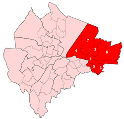
 Map showing Victoria wards within Belfast |
|
| Area | 20.2 km2 (7.8 sq mi) |
| Population | 36,607 (2008 Estimate) |
| • Density | 1,812/km2 (4,690/sq mi) |
| District | |
| County | |
| Country | Northern Ireland |
| Sovereign state | United Kingdom |
| EU Parliament | Northern Ireland |
| UK Parliament | |
| NI Assembly | |
Victoria was one of the nine district electoral areas (DEA) in Belfast, Northern Ireland, from 1985 to 2014, when it was mostly replaced by the Ormiston district.
Located in the east of the city, the district elected seven members to Belfast City Council and contained the wards of Ballyhackamore; Belmont; Cherryvalley; Island; Knock; Stormont; and Sydenham. Victoria, along with wards from the neighbouring Pottinger district and Castlereagh Borough Council, formed the Belfast East constituency for the Northern Ireland Assembly and UK Parliament.
The district was bounded to the west by the Victoria Channel, to the north by Belfast Lough, to the northeast by North Down Borough Council, to the south and east by Castlereagh Borough Council and to the southwest by the Newtownards Road.
The DEA was created for the 1985 local elections as the successor to the former Area B, which all seven wards in the new Victoria had been part of. An eighth ward, Bloomfield, which had been in Area B, was placed in the new Pottinger electoral area. It will be abolished in 2015, having made way for the new DEAs that were used for the 2014 local elections. It will largely be replaced by the new Ormiston District Electoral Area. Five of Victoria's wards joined Ormiston, with the Sydenham ward and the areas which had been part of the abolished Island ward becoming part of the new Titanic District Electoral Area.
...
Wikipedia
