Vauffelin
| Vauffelin | ||
|---|---|---|
| Former municipality of Switzerland | ||

Frinvillier village main street
|
||
|
||
| Coordinates: 47°11′N 7°18′E / 47.183°N 7.300°ECoordinates: 47°11′N 7°18′E / 47.183°N 7.300°E | ||
| Country | Switzerland | |
| Canton | Bern | |
| District | Jura bernois | |
| Area | ||
| • Total | 5.92 km2 (2.29 sq mi) | |
| Elevation | 707 m (2,320 ft) | |
| Population (Dec 2011) | ||
| • Total | 427 | |
| • Density | 72/km2 (190/sq mi) | |
| Postal code | 2537 | |
| SFOS number | 0447 | |
| Surrounded by | Orvin, Péry, Plagne, Romont, Pieterlen, Biel/Bienne | |
| Website |
www SFSO statistics |
|
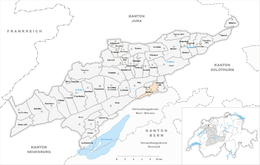
Vauffelin is a former municipality in the Jura bernois administrative district in the canton of Bern in Switzerland. It is located in the French-speaking Bernese Jura (Jura Bernois). On 1 January 2014 the former municipalities of Vauffelin and Plagne merged into the new municipality of Sauge.
Vauffelin and its parish is first mentioned in the Lausanne Chartular of 1228 as Vualfelim. It was formerly known by its German names Füglistal or Füglisthal though this name is no longer used. The village of Frinvillier was first mentioned in 1393 as Frunwelier.
Frinvillier was located at the intersection of two important Roman roads, one leading from Petinesca (now Studen) over the Pierre Pertuis pass to Augusta Raurica (near Augst) and the road from Eburodunum (now Yverdon) over the Plateau de Diesse to Salodurum (Solothurn). A watch tower was built on at Rondchâtel to guard the road.
In 1364, Count Thierstein granted the patronage rights of the village church to the Church of St. Benedict in Biel. During the Late Middle Ages and the Early Modern Era it was part of the seigniory of Erguel under the Prince-Bishop of Basel. After the 1797 French victory and the Treaty of Campo Formio, Vauffelin became part of the French Département of Mont-Terrible. Three years later, in 1800 it became part of the Département of Haut-Rhin. After Napoleon's defeat and the Congress of Vienna, Vauffelin was assigned to the Canton of Bern in 1815.
...
Wikipedia


