Vasilevsky Island
| Native name: Васильевский остров | |
|---|---|

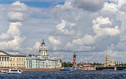
Spit of Vasilyevsky Island. View to Universitetskaya Embankment, Kunstkamera museum and Peter and Paul Fortress
|
|
| Geography | |
| Location | Gulf of Finland |
| Coordinates | 59°56′N 30°16′E / 59.94°N 30.26°ECoordinates: 59°56′N 30°16′E / 59.94°N 30.26°E |
| Area | 19.3 km2 (7.5 sq mi) |
| Administration | |
|
Russia
|
|
| City | Saint Petersburg |
| Demographics | |
| Population | 209,188 (2017) |
| Pop. density | 10,833 /km2 (28,057 /sq mi) |
| Ethnic groups | Russians |
Vasilyevsky Island (Russian: Васи́льевский о́стров, Vasilyevsky Ostrov, V.O.) is an island in St. Petersburg, Russia, bordered by the Bolshaya Neva and Malaya Neva Rivers (in the delta of the Neva River) in the south and northeast, and by the Gulf of Finland in the west. Vasilyevsky Island is separated from Dekabristov Island by the Smolenka River. Together they form the territory of Vasileostrovsky District, an administrative division of Saint Petersburg.
Situated just across the river from the Winter Palace, it constitutes a large portion of the city's historic center. Two of the most famous St. Petersburg bridges, Palace Bridge and Blagoveshchensky Bridge, connect it with the mainland to the south. The Exchange Bridge and Tuchkov Bridge across the Malaya Neva connect it with Petrogradsky Island. Vasilyevsky Island is served by Vasileostrovskaya and Primorskaya stations of Saint Petersburg Metro (Line 3 ![]() ). There are also tramway lines.
). There are also tramway lines.
...
Wikipedia

