
Varel
| Varel | ||
|---|---|---|

Pedestrian area in Varel
|
||
|
||

Varel
|
||
|
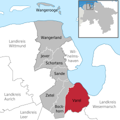
Location of Varel within Friesland district
  |
||
| Coordinates: 53°23′49″N 08°08′10″E / 53.39694°N 8.13611°ECoordinates: 53°23′49″N 08°08′10″E / 53.39694°N 8.13611°E | ||
| Country | Germany | |
| State | Lower Saxony | |
| District | Friesland | |
| Government | ||
| • Mayor | Gerd-Christian Wagner (SPD) | |
| Area | ||
| • Total | 113.53 km2 (43.83 sq mi) | |
| Elevation | 0 - 12 m (−39 ft) | |
| Population (2015-12-31) | ||
| • Total | 23,884 | |
| • Density | 210/km2 (540/sq mi) | |
| Time zone | CET/CEST (UTC+1/+2) | |
| Postal codes | 26316 | |
| Dialling codes | 04451 | |
| Vehicle registration | FRI | |
| Website | www.varel.de | |

Varel ([ˈfaːʁəl]) is a town in the district of Friesland, in Lower Saxony, Germany. It is situated near the Jade River and the Jade Bight, approximately 15 kilometres (9.3 mi) south of Wilhelmshaven and 30 kilometres (19 mi) north of Oldenburg.
The castle church is the oldest building in Varel. The first part of the church is believed to have been built in 1144. The tower was added between 1200 and 1250, originally as twin towers, which were rebuilt in today's form first in 1651 and then in 1737. The altar, font and pulpit were carved in 1613 – 1618 by Ludwig Münstermann. The altar is nearly 10 metres (33 ft) high and is one of the main works of Northern German Mannerism.
Before the Protestant Reformation, the patron saint was Saint Peter. Today, the castle church is a Lutheran church, with no patron saint. The church was formerly one of the buildings of the castle, which was demolished in the 19th century soon after a fire destroyed most parts of it.
Varel is twinned with:
...
Wikipedia