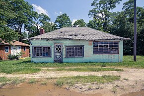
Vandalia, Indiana
| Vandalia, Indiana | |
|---|---|
| Unincorporated community | |
 |
|
| Coordinates: 39°18′45″N 86°51′58″W / 39.31250°N 86.86611°WCoordinates: 39°18′45″N 86°51′58″W / 39.31250°N 86.86611°W | |
| Country | United States |
| State | Indiana |
| County | Owen |
| Township | Lafayette |
| Elevation | 787 ft (240 m) |
| Time zone | Eastern (EST) (UTC-5) |
| • Summer (DST) | EDT (UTC-4) |
| ZIP code | 47868 |
| Area code(s) | 812, 930 |
| GNIS feature ID | 445224 |
Vandalia is an unincorporated community in Lafayette Township, Owen County, in the U.S. state of Indiana.
Vandalia was laid out in 1839. A post office was established at Vandalia in 1846, and remained in operation until it was discontinued in 1927.
Vandalia is located at 39°18′45″N 86°51′58″W / 39.31250°N 86.86611°W at an elevation of 787 feet. It lies at the east end of State Road 246 where it intersects State Road 46.
...
Wikipedia


