Vallorbe
| Vallorbe | ||
|---|---|---|

Vallorbe
|
||
|
||
| Coordinates: 46°43′N 06°23′E / 46.717°N 6.383°ECoordinates: 46°43′N 06°23′E / 46.717°N 6.383°E | ||
| Country | Switzerland | |
| Canton | Vaud | |
| District | Jura-Nord Vaudois | |
| Government | ||
| • Mayor |
Syndic Stéphane Costantini LPS/PLS (as of 2008) |
|
| Area | ||
| • Total | 23.19 km2 (8.95 sq mi) | |
| Elevation | 770 m (2,530 ft) | |
| Highest elevation (At Dent de Vaulion) | 1,480 m (4,860 ft) | |
| Lowest elevation (Orbe) | 610 m (2,000 ft) | |
| Population (Dec 2015) | ||
| • Total | 3,654 | |
| • Density | 160/km2 (410/sq mi) | |
| Demonym(s) | Les Vallorbiers Les Tire-Lune |
|
| Postal code | 1337 | |
| SFOS number | 5764 | |
| Localities | Le Creux, Le Day | |
| Surrounded by | Ballaigues, Les Clées, Premier, Vaulion, L'Abbaye, Le Lieu, France (pays) | |
| Website |
www Profile (French), SFSO statistics |
|
Vallorbe is a municipality in the district of Jura-Nord Vaudois in the canton of Vaud in Switzerland.
Vallorbe is first mentioned in 1139 as de valle urbanensi. In 1148 it was mentioned as de valle urbe.
Vallorbe has an area, as of 2009[update], of 23.2 square kilometers (9.0 sq mi). Of this area, 5.12 km2 (1.98 sq mi) or 22.1% is used for agricultural purposes, while 15.47 km2 (5.97 sq mi) or 66.7% is forested. Of the rest of the land, 2.17 km2 (0.84 sq mi) or 9.4% is settled (buildings or roads), 0.28 km2 (0.11 sq mi) or 1.2% is either rivers or lakes and 0.15 km2 (37 acres) or 0.6% is unproductive land.
Of the built up area, housing and buildings made up 3.5% and transportation infrastructure made up 4.3%. Out of the forested land, 64.6% of the total land area is heavily forested and 2.2% is covered with orchards or small clusters of trees. Of the agricultural land, 1.4% is used for growing crops and 16.6% is pastures and 3.9% is used for alpine pastures. Of the water in the municipality, 0.4% is in lakes and 0.8% is in rivers and streams.
The municipality was part of the Orbe District until it was dissolved on 31 August 2006, and Vallorbe became part of the new district of Jura-Nord Vaudois.
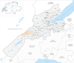
The municipality is located on the Swiss-French border. It is surrounded on three sides with mountains and reaches from 610 to 1,480 m (2,000 to 4,860 ft) in elevation. On the east side, the valley opens up due to the Jougnenaz and Orbe rivers. It includes the hamlets of Le Day, Le Creux and Bellevue.
The blazon of the municipal coat of arms is Or, on a Bend wavy Azure a Trout proper bendwise.
Vallorbe has a population (as of December 2015[update]) of 3,654. As of 2008[update], 23.1% of the population are resident foreign nationals. Over the last 10 years (1999–2009 ) the population has changed at a rate of 7.2%. It has changed at a rate of 10% due to migration and at a rate of -1.8% due to births and deaths.
...
Wikipedia


