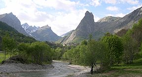
Val Maira
| Maira Valley | |
|---|---|
| Val Maira, Valle Macra | |

The highest part of the valley
|
|

Location of the valley in Piedmont, NW Italy
|
|
| Location | Piedmont, Italy |
| Floor elevation | 500–3,412 m (1,640–11,194 ft) |
| Long-axis direction | west east |
| Long-axis length | around 45 km (28 mi) |
| Geology | |
| Type | River valley |
| Geography | |
| Coordinates | 44°30′07″N 7°08′16″E / 44.50194°N 7.13778°ECoordinates: 44°30′07″N 7°08′16″E / 44.50194°N 7.13778°E |
Maira Valley (in Italian Val Maira or Valle Macra) is a valley in south-west of Piedmont in the Province of Cuneo, Italy.
The valley takes its name from the river Maira, a right-hand tributary of the Po which flows through the valley.
The municipalities of the valley are Busca, Villar San Costanzo, Dronero, Roccabruna, Cartignano, San Damiano Macra, Macra, Celle di Macra, Stroppo, Elva, Canosio, Marmora, Prazzo and Acceglio.
Among the notable summits which surround the valley (all of them belonging to the Cottian Alps) there are:
...
Wikipedia
