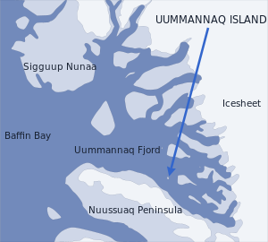
Uummannaq Island

Location of Uummannaq Island
|
|
| Geography | |
|---|---|
| Location | Uummannaq Fjord |
| Coordinates | 70°42′11″N 52°08′00″W / 70.70306°N 52.13333°WCoordinates: 70°42′11″N 52°08′00″W / 70.70306°N 52.13333°W |
| Area | 12 km2 (4.6 sq mi) |
| Administration | |
|
Greenland
|
|
| Municipality | Qaasuitsup |
Uummannaq Island (Greenlandic: Uummannap qeqertaa) is a small (12 km2) island in the Qaasuitsup municipality in northwestern Greenland. Located in the south-central part of the Uummannaq Fjord, it is home to the most prominent mountain on the Arctic coast of western Greenland and to Uummannaq, the largest town north of Ilulissat.
The island is separated from Nuussuaq Peninsula in the southwest by Sarqarput Strait in the southern arm of Uummannaq Fjord. In the east, the island is separated from the Salliaruseq Island by the wide Assorput Strait. To the north, the central arm of Uummannaq Fjord separates it from the large Appat Island and the skerries of Saattut.
The island has a very undeveloped coast, with a handful of small, rocky bays primarily in the southernmost, inhabited part. The only significant bay is Qasigissat (Danish: Spraglebugten) on the southwestern shore. The weakly indented Iterlak bay is located on the northwestern coast of the island. The sea is the only means of transport to the uninhabited northern part of the island.
The Uummannaq port occupies a small inlet in the southeastern end of the island. It is not deep enough to service large cruise ships, but sufficiently deep to handle supply and fishing ships of Royal Arctic Line and Royal Greenland, as well as motorboats and lesser fishing boats. There are several small bays between the port and Nuussuatsiaq promontory, in the vicinity of the heliport.
Fishermen of Uummannaq town peruse the entire southern coast for anchorage of smaller fishing boats and motorboats. Outside the urbanized part of the island there are several inlets and coves providing protection for fishing nets and, in the summer, dogsleds. During summertime, a small and otherwise economically uninteresting skerry in Qasigissat Bay is used as an observation point for marine life, particularly fish schools migrating alongside the coast.
...
Wikipedia
