Ushiku, Ibaraki
|
Ushiku 牛久市 |
|||
|---|---|---|---|
| City | |||

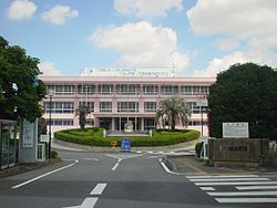
Ushiku city hall
|
|||
|
|||
 Location of Ushiku in Ibaraki Prefecture |
|||
| Coordinates: 35°58′45.7″N 140°8′58.4″E / 35.979361°N 140.149556°ECoordinates: 35°58′45.7″N 140°8′58.4″E / 35.979361°N 140.149556°E | |||
| Country | Japan | ||
| Region | Kantō | ||
| Prefecture | Ibaraki Prefecture | ||
| Area | |||
| • Total | 58.92 km2 (22.75 sq mi) | ||
| Population (September 2015) | |||
| • Total | 84,285 | ||
| • Density | 1,430/km2 (3,700/sq mi) | ||
| Time zone | Japan Standard Time (UTC+9) | ||
| - Tree | Osmanthus fragrans | ||
| - Flower | Chrysanthemum | ||
| - Bird | Japanese bush warbler | ||
| Phone number | 029-873-2111 | ||
| Address | 3-15-1 Chuo, Ushiku-shi, Ibaraki-ken 300-1292 | ||
| Website | Official website | ||
Ushiku (牛久市 Ushiku-shi?) is a city located in Ibaraki Prefecture, in the northern Kantō region of Japan. As of September 2015, the city had an estimated population of 84,285 and a population density of 1,430 persons per km². Its total area was 58.92 square kilometres (22.75 sq mi).
Ushiku is located in southern Ibaraki Prefecture, in the low-lying marshy flatlands south of Lake Kasumigaura. It is about 50 kilometers from central Tokyo.
The area of Ushuku developed as a castle town around Ushiku Domain under the Tokugawa shogunate in the Edo period.
The village of Ushiku was created with the establishment of the municipalities system on April 1, 1889. On January 1, 1954 it was elevated to town status and to city status on June 1, 1986.
Ushiku is a local commercial center and has a small industrial park, however, the local economy remains based on agriculture, primarily rice cultivation .
Ushiku has eight elementary schools, six middle schools, and four high schools.
...
Wikipedia


