Uruma
|
Uruma うるま市 |
|||
|---|---|---|---|
| City | |||

|
|||
|
|||
 Location of Uruma in Okinawa Prefecture |
|||
| Coordinates: 26°22′45″N 127°51′27″E / 26.37917°N 127.85750°ECoordinates: 26°22′45″N 127°51′27″E / 26.37917°N 127.85750°E | |||
| Country | Japan | ||
| Region | Kyushu | ||
| Prefecture | Okinawa Prefecture | ||
| Government | |||
| • Mayor | Toshio Shimabukuro | ||
| Area | |||
| • Total | 86.00 km2 (33.20 sq mi) | ||
| Elevation | 204 m (669 ft) | ||
| Population (May 1, 2013) | |||
| • Total | 118,330 | ||
| • Density | 1,400/km2 (3,600/sq mi) | ||
| Time zone | Japan Standard Time (UTC+9) | ||
| - Tree | Ryuūkyū kuroki (Symplocos lucida Sieb. et Zucc) |
||
| - Flower | Sandanka (Ixosora chinensis) |
||
| - Flowering tree | Hibiscus | ||
| - Bird | Chaan (Ryukyuan cock) | ||
| Phone number | 098-974-3111 | ||
| Address | 1-1-1 Midori-machi, Uruma-shi, Okinawa-ken 904-2292 |
||
| Website |
www |
||
Uruma (うるま市 Uruma-shi?) is a city located in Okinawa Prefecture, Japan.
As of May 1, 2013, the city has an estimated population of 118,330 and a population density of 1,400 persons per km². The total area is 86.00 km².
The modern city of Uruma was established on April 1, 2005, when the cities of Gushikawa and Ishikawa were merged with the towns of Katsuren and Yonashiro (both from Nakagami District).
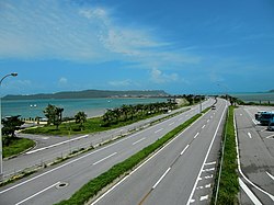
The city covers part of the east coast of the south of Okinawa Island, the Katsuren Peninsula, and the eight Yokatsu Islands. The Yokatsu Islands include numerous sites important to the Ryukyuan religion, and the city as a whole has numerous historical sites, including: Katsuren Castle, Agena Castle, and Iha Castle and the Iha Shell Mound.
Uruma is noted for its role in hosting large-scale refugee camps and the initial organization of local government of Okinawa immediately after the Battle of Okinawa in 1945. As such the city is considered the home of the starting point of the restoration of civil life in Okinawa immediately after the end of World War II.
...
Wikipedia


